You are here: Home > Network List > TA - USArray Transportable Network (new EarthScope stations) Stations List
> Station J05D Fort Rock, OR, USA > Earthquake Result Viewer
J05D Fort Rock, OR, USA - Earthquake Result Viewer
| Earthquake location: |
Near Coast Of Guatemala |
| Earthquake latitude/longitude: |
13.5/-91.4 |
| Earthquake time(UTC): |
2013/05/12 (132) 07:29:59 GMT |
| Earthquake Depth: |
11 km |
| Earthquake Magnitude: |
5.5 MS, 5.2 MB, 5.8 MW, 5.6 MW |
| Earthquake Catalog/Contributor: |
WHDF/NEIC |
|
| Network: |
TA USArray Transportable Network (new EarthScope stations) |
| Station: |
J05D Fort Rock, OR, USA |
| Lat/Lon: |
43.28 N/121.23 W |
| Elevation: |
1541 m |
|
| Distance: |
39.3 deg |
| Az: |
324.935 deg |
| Baz: |
130.062 deg |
| Ray Param: |
0.075085364 |
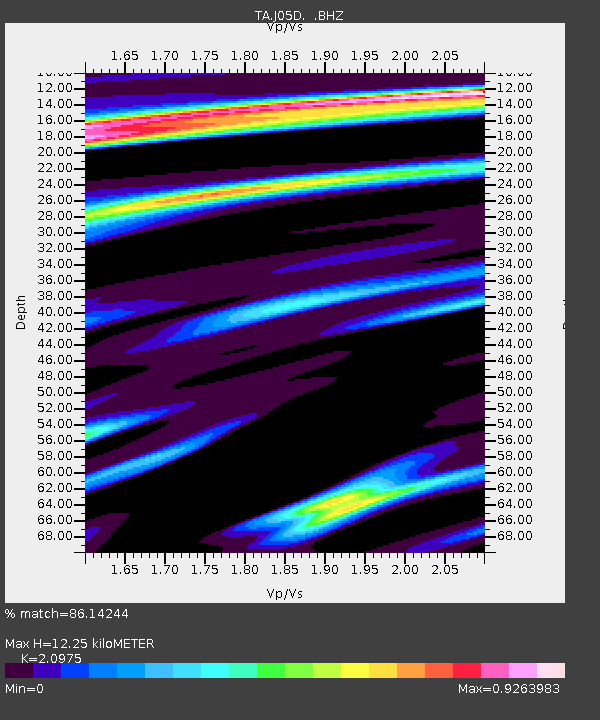
| Estimated Moho Depth: |
12.25 km |
| Estimated Crust Vp/Vs: |
2.10 |
| Assumed Crust Vp: |
6.597 km/s |
| Estimated Crust Vs: |
3.145 km/s |
| Estimated Crust Poisson's Ratio: |
0.35 |
|
| Radial Match: |
86.14244 % |
| Radial Bump: |
400 |
| Transverse Match: |
79.5234 % |
| Transverse Bump: |
400 |
| SOD ConfigId: |
512894 |
| Insert Time: |
2013-09-14 01:27:27.501 +0000 |
| GWidth: |
2.5 |
| Max Bumps: |
400 |
| Tol: |
0.001 |
|
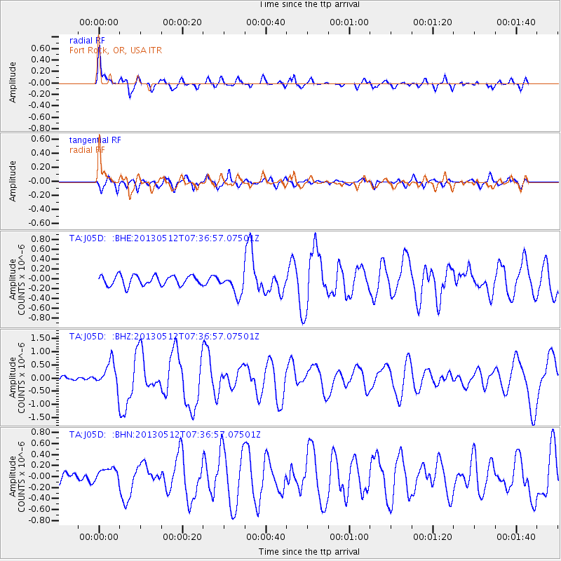
Signal To Noise
| Channel | StoN | STA | LTA |
| TA:J05D: :BHZ:20130512T07:36:57.07501Z | 5.0663533 | 5.1529E-7 | 1.0170827E-7 |
| TA:J05D: :BHN:20130512T07:36:57.07501Z | 1.3138235 | 1.2541544E-7 | 9.545836E-8 |
| TA:J05D: :BHE:20130512T07:36:57.07501Z | 2.2020237 | 2.2046254E-7 | 1.0011815E-7 |
| Arrivals |
| Ps | 2.2 SECOND |
| PpPs | 5.4 SECOND |
| PsPs/PpSs | 7.6 SECOND |


