You are here: Home > Network List > UU - University of Utah Regional Network Stations List
> Station PKCU Pink Cliffs, UT, USA > Earthquake Result Viewer
PKCU Pink Cliffs, UT, USA - Earthquake Result Viewer
| Earthquake location: |
Near Coast Of Guatemala |
| Earthquake latitude/longitude: |
13.5/-91.4 |
| Earthquake time(UTC): |
2013/05/12 (132) 07:29:59 GMT |
| Earthquake Depth: |
11 km |
| Earthquake Magnitude: |
5.5 MS, 5.2 MB, 5.8 MW, 5.6 MW |
| Earthquake Catalog/Contributor: |
WHDF/NEIC |
|
| Network: |
UU University of Utah Regional Network |
| Station: |
PKCU Pink Cliffs, UT, USA |
| Lat/Lon: |
37.44 N/112.31 W |
| Elevation: |
2834 m |
|
| Distance: |
30.3 deg |
| Az: |
325.695 deg |
| Baz: |
136.459 deg |
| Ray Param: |
0.079365976 |
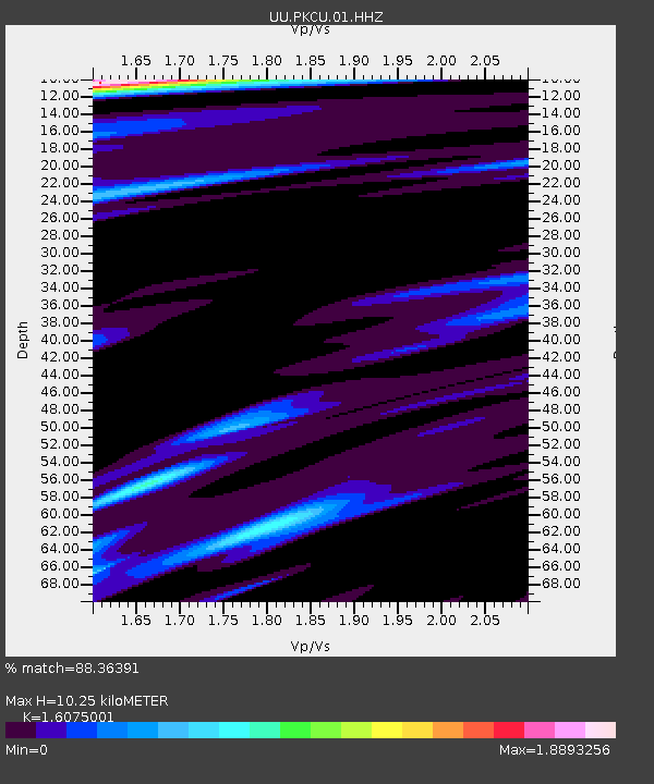
| Estimated Moho Depth: |
10.25 km |
| Estimated Crust Vp/Vs: |
1.61 |
| Assumed Crust Vp: |
6.194 km/s |
| Estimated Crust Vs: |
3.853 km/s |
| Estimated Crust Poisson's Ratio: |
0.18 |
|
| Radial Match: |
88.36391 % |
| Radial Bump: |
312 |
| Transverse Match: |
82.058044 % |
| Transverse Bump: |
377 |
| SOD ConfigId: |
512894 |
| Insert Time: |
2013-09-14 01:30:29.174 +0000 |
| GWidth: |
2.5 |
| Max Bumps: |
400 |
| Tol: |
0.001 |
|

Signal To Noise
| Channel | StoN | STA | LTA |
| UU:PKCU:01:HHZ:20130512T07:35:39.999998Z | 6.1287193 | 2.0177211E-8 | 3.2922396E-9 |
| UU:PKCU:01:HHN:20130512T07:35:39.999998Z | 1.2756883 | 5.4425335E-9 | 4.2663504E-9 |
| UU:PKCU:01:HHE:20130512T07:35:39.999998Z | 1.6418059 | 7.603451E-9 | 4.631151E-9 |
| Arrivals |
| Ps | 1.1 SECOND |
| PpPs | 4.0 SECOND |
| PsPs/PpSs | 5.1 SECOND |


