You are here: Home > Network List > UU - University of Utah Regional Network Stations List
> Station TMU Trail Mountain (BB), UT, USA > Earthquake Result Viewer
TMU Trail Mountain (BB), UT, USA - Earthquake Result Viewer
| Earthquake location: |
Near Coast Of Guatemala |
| Earthquake latitude/longitude: |
13.5/-91.4 |
| Earthquake time(UTC): |
2013/05/12 (132) 07:29:59 GMT |
| Earthquake Depth: |
11 km |
| Earthquake Magnitude: |
5.5 MS, 5.2 MB, 5.8 MW, 5.6 MW |
| Earthquake Catalog/Contributor: |
WHDF/NEIC |
|
| Network: |
UU University of Utah Regional Network |
| Station: |
TMU Trail Mountain (BB), UT, USA |
| Lat/Lon: |
39.30 N/111.21 W |
| Elevation: |
2731 m |
|
| Distance: |
31.1 deg |
| Az: |
329.37 deg |
| Baz: |
140.302 deg |
| Ray Param: |
0.07915388 |
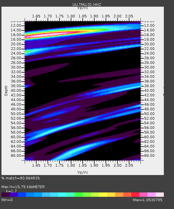
| Estimated Moho Depth: |
15.75 km |
| Estimated Crust Vp/Vs: |
1.70 |
| Assumed Crust Vp: |
6.207 km/s |
| Estimated Crust Vs: |
3.651 km/s |
| Estimated Crust Poisson's Ratio: |
0.24 |
|
| Radial Match: |
90.964935 % |
| Radial Bump: |
310 |
| Transverse Match: |
88.846985 % |
| Transverse Bump: |
400 |
| SOD ConfigId: |
512894 |
| Insert Time: |
2013-09-14 01:30:51.575 +0000 |
| GWidth: |
2.5 |
| Max Bumps: |
400 |
| Tol: |
0.001 |
|

Signal To Noise
| Channel | StoN | STA | LTA |
| UU:TMU:01:HHZ:20130512T07:35:47.118986Z | 7.3827496 | 1.7818808E-8 | 2.4135736E-9 |
| UU:TMU:01:HHN:20130512T07:35:47.118986Z | 3.2748275 | 6.879339E-9 | 2.100672E-9 |
| UU:TMU:01:HHE:20130512T07:35:47.118986Z | 3.798897 | 6.528792E-9 | 1.718602E-9 |
| Arrivals |
| Ps | 1.9 SECOND |
| PpPs | 6.3 SECOND |
| PsPs/PpSs | 8.3 SECOND |


