You are here: Home > Network List > UW - Pacific Northwest Regional Seismic Network Stations List
> Station BLOW Detroit Lake, OR, USA > Earthquake Result Viewer
BLOW Detroit Lake, OR, USA - Earthquake Result Viewer

| Earthquake location: |
Near Coast Of Guatemala |
| Earthquake latitude/longitude: |
13.5/-91.4 |
| Earthquake time(UTC): |
2013/05/12 (132) 07:29:59 GMT |
| Earthquake Depth: |
11 km |
| Earthquake Magnitude: |
5.5 MS, 5.2 MB, 5.8 MW, 5.6 MW |
| Earthquake Catalog/Contributor: |
WHDF/NEIC |
|
| Network: |
UW Pacific Northwest Regional Seismic Network |
| Station: |
BLOW Detroit Lake, OR, USA |
| Lat/Lon: |
44.68 N/122.19 W |
| Elevation: |
652 m |
|
| Distance: |
40.7 deg |
| Az: |
325.911 deg |
| Baz: |
130.151 deg |
| Ray Param: |
0.07425414 |
| Estimated Moho Depth: |
24.25 km |
| Estimated Crust Vp/Vs: |
1.87 |
| Assumed Crust Vp: |
6.566 km/s |
| Estimated Crust Vs: |
3.507 km/s |
| Estimated Crust Poisson's Ratio: |
0.30 |
|
| Radial Match: |
89.724754 % |
| Radial Bump: |
400 |
| Transverse Match: |
80.352585 % |
| Transverse Bump: |
400 |
| SOD ConfigId: |
512894 |
| Insert Time: |
2013-09-14 01:31:03.464 +0000 |
| GWidth: |
2.5 |
| Max Bumps: |
400 |
| Tol: |
0.001 |
|
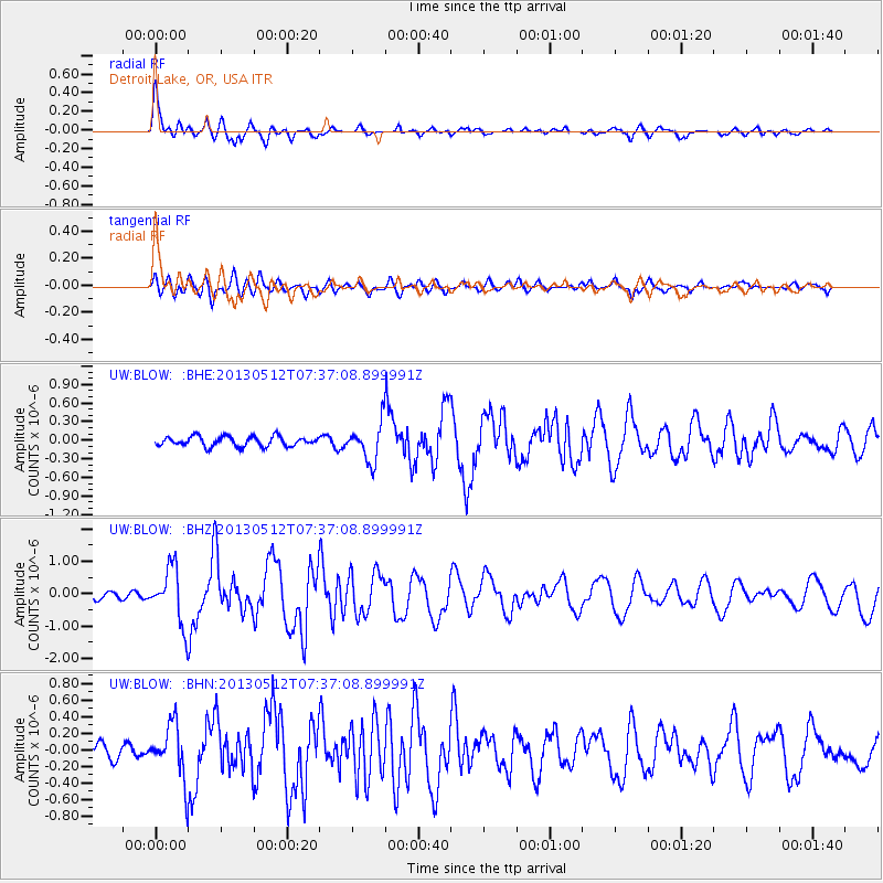
Signal To Noise
| Channel | StoN | STA | LTA |
| UW:BLOW: :BHZ:20130512T07:37:08.899991Z | 9.021639 | 8.564608E-7 | 9.4934066E-8 |
| UW:BLOW: :BHN:20130512T07:37:08.899991Z | 4.9889975 | 3.23093E-7 | 6.47611E-8 |
| UW:BLOW: :BHE:20130512T07:37:08.899991Z | 3.791606 | 2.9975573E-7 | 7.905772E-8 |
| Arrivals |
| Ps | 3.5 SECOND |
| PpPs | 9.9 SECOND |
| PsPs/PpSs | 13 SECOND |


