You are here: Home > Network List > PS - Pacific21 Stations List
> Station PSI Parapat, Indonesia > Earthquake Result Viewer
PSI Parapat, Indonesia - Earthquake Result Viewer
*The percent match for this event was below the threshold and hence no stack was calculated.
| Earthquake location: |
South Of Fiji Islands |
| Earthquake latitude/longitude: |
-22.3/-179.7 |
| Earthquake time(UTC): |
1997/12/26 (360) 05:34:24 GMT |
| Earthquake Depth: |
588 km |
| Earthquake Magnitude: |
5.9 UNKNOWN, 5.3 MB, 5.8 MW |
| Earthquake Catalog/Contributor: |
WHDF/NEIC |
|
| Network: |
PS Pacific21 |
| Station: |
PSI Parapat, Indonesia |
| Lat/Lon: |
2.69 N/98.92 E |
| Elevation: |
987 m |
|
| Distance: |
83.1 deg |
| Az: |
275.768 deg |
| Baz: |
112.755 deg |
| Ray Param: |
$rayparam |
*The percent match for this event was below the threshold and hence was not used in the summary stack. |
|
| Radial Match: |
62.16181 % |
| Radial Bump: |
400 |
| Transverse Match: |
65.98068 % |
| Transverse Bump: |
400 |
| SOD ConfigId: |
4480 |
| Insert Time: |
2010-02-27 03:28:52.336 +0000 |
| GWidth: |
2.5 |
| Max Bumps: |
400 |
| Tol: |
0.001 |
|
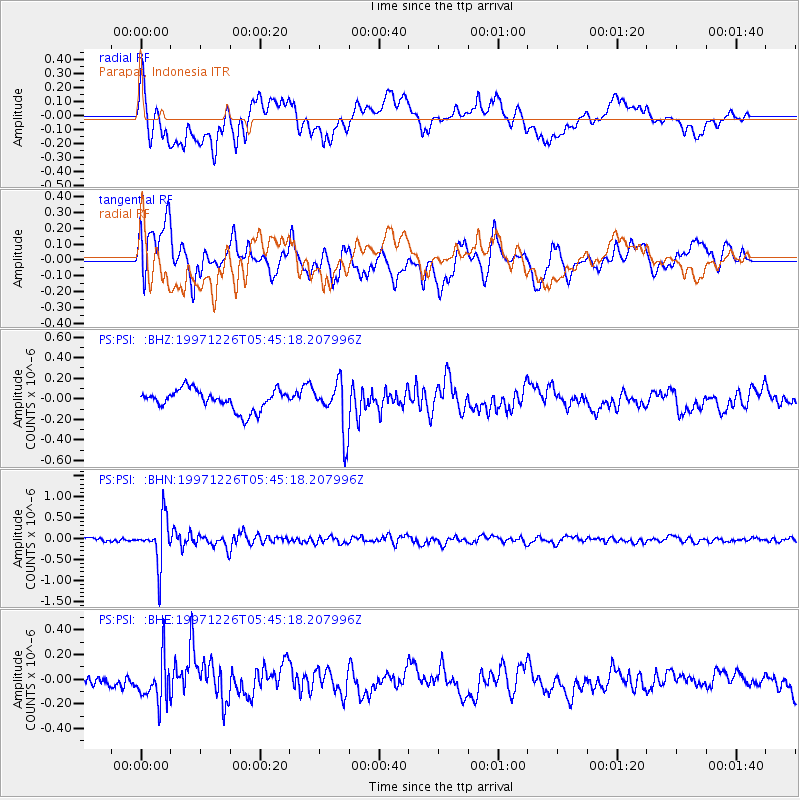
Signal To Noise
| Channel | StoN | STA | LTA |
| PS:PSI: :BHN:19971226T05:45:18.207996Z | 10.049581 | 5.4144874E-7 | 5.3877745E-8 |
| PS:PSI: :BHE:19971226T05:45:18.207996Z | 2.385311 | 1.688063E-7 | 7.07691E-8 |
| PS:PSI: :BHZ:19971226T05:45:18.207996Z | 2.5178077 | 2.4707276E-7 | 9.813011E-8 |
| Arrivals |
| Ps | |
| PpPs | |
| PsPs/PpSs | |


