You are here: Home > Network List > PS - Pacific21 Stations List
> Station PSI Parapat, Indonesia > Earthquake Result Viewer
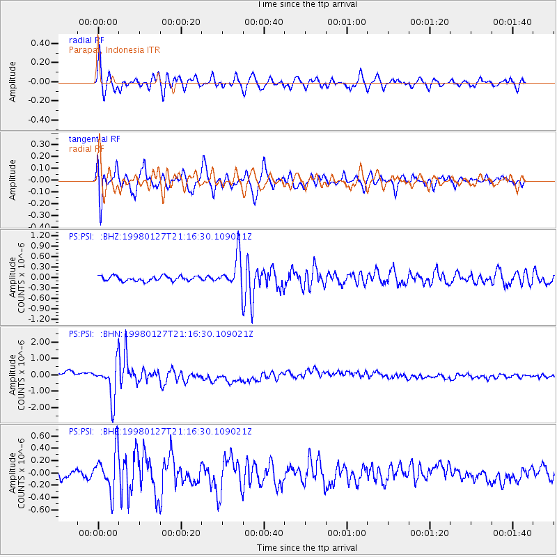
PSI Parapat, Indonesia - Earthquake Result Viewer
*The percent match for this event was below the threshold and hence no stack was calculated.
| Earthquake location: |
South Of Fiji Islands |
| Earthquake latitude/longitude: |
-22.4/179.0 |
| Earthquake time(UTC): |
1998/01/27 (027) 21:05:44 GMT |
| Earthquake Depth: |
610 km |
| Earthquake Magnitude: |
5.6 MB, 6.5 UNKNOWN, 6.4 MW |
| Earthquake Catalog/Contributor: |
WHDF/NEIC |
|
| Network: |
PS Pacific21 |
| Station: |
PSI Parapat, Indonesia |
| Lat/Lon: |
2.69 N/98.92 E |
| Elevation: |
987 m |
|
| Distance: |
81.9 deg |
| Az: |
276.276 deg |
| Baz: |
112.952 deg |
| Ray Param: |
$rayparam |
*The percent match for this event was below the threshold and hence was not used in the summary stack. |
|
| Radial Match: |
81.510185 % |
| Radial Bump: |
400 |
| Transverse Match: |
81.50351 % |
| Transverse Bump: |
400 |
| SOD ConfigId: |
4480 |
| Insert Time: |
2010-02-27 03:29:16.586 +0000 |
| GWidth: |
2.5 |
| Max Bumps: |
400 |
| Tol: |
0.001 |
|
Signal To Noise
| Channel | StoN | STA | LTA |
| PS:PSI: :BHN:19980127T21:16:30.109021Z | 3.8362253 | 1.155067E-6 | 3.0109467E-7 |
| PS:PSI: :BHE:19980127T21:16:30.109021Z | 5.636008 | 3.4320036E-7 | 6.089423E-8 |
| PS:PSI: :BHZ:19980127T21:16:30.109021Z | 7.0702395 | 4.899404E-7 | 6.9296156E-8 |
| Arrivals |
| Ps | |
| PpPs | |
| PsPs/PpSs | |


