You are here: Home > Network List > TA - USArray Transportable Network (new EarthScope stations) Stations List
> Station L40A Anamosa, IA, USA > Earthquake Result Viewer
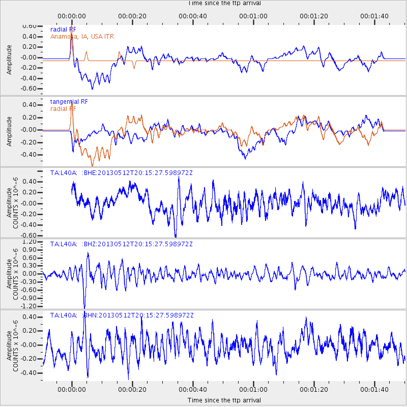
L40A Anamosa, IA, USA - Earthquake Result Viewer
*The percent match for this event was below the threshold and hence no stack was calculated.
| Earthquake location: |
Fox Islands, Aleutian Islands |
| Earthquake latitude/longitude: |
52.5/-172.0 |
| Earthquake time(UTC): |
2013/05/12 (132) 20:06:41 GMT |
| Earthquake Depth: |
8.0 km |
| Earthquake Magnitude: |
5.7 MB, 5.1 MS, 5.4 MW, 5.3 MW |
| Earthquake Catalog/Contributor: |
WHDF/NEIC |
|
| Network: |
TA USArray Transportable Network (new EarthScope stations) |
| Station: |
L40A Anamosa, IA, USA |
| Lat/Lon: |
42.06 N/91.22 W |
| Elevation: |
242 m |
|
| Distance: |
53.0 deg |
| Az: |
66.921 deg |
| Baz: |
310.948 deg |
| Ray Param: |
$rayparam |
*The percent match for this event was below the threshold and hence was not used in the summary stack. |
|
| Radial Match: |
55.599976 % |
| Radial Bump: |
400 |
| Transverse Match: |
33.89754 % |
| Transverse Bump: |
400 |
| SOD ConfigId: |
512894 |
| Insert Time: |
2013-09-14 02:49:12.994 +0000 |
| GWidth: |
2.5 |
| Max Bumps: |
400 |
| Tol: |
0.001 |
|
Signal To Noise
| Channel | StoN | STA | LTA |
| TA:L40A: :BHZ:20130512T20:15:27.598972Z | 3.7881906 | 4.2900936E-7 | 1.1324914E-7 |
| TA:L40A: :BHN:20130512T20:15:27.598972Z | 0.85199666 | 2.4541436E-7 | 2.8804615E-7 |
| TA:L40A: :BHE:20130512T20:15:27.598972Z | 2.2165065 | 3.5014418E-7 | 1.5797119E-7 |
| Arrivals |
| Ps | |
| PpPs | |
| PsPs/PpSs | |


