You are here: Home > Network List > TA - USArray Transportable Network (new EarthScope stations) Stations List
> Station L48A N Adams, MI, USA > Earthquake Result Viewer
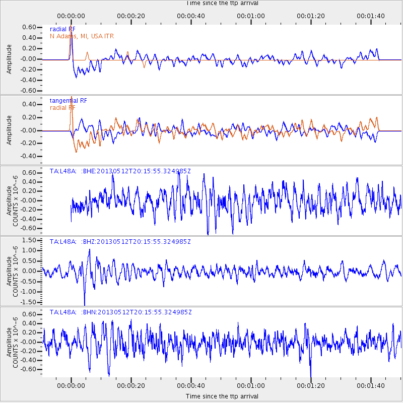
L48A N Adams, MI, USA - Earthquake Result Viewer
*The percent match for this event was below the threshold and hence no stack was calculated.
| Earthquake location: |
Fox Islands, Aleutian Islands |
| Earthquake latitude/longitude: |
52.5/-172.0 |
| Earthquake time(UTC): |
2013/05/12 (132) 20:06:41 GMT |
| Earthquake Depth: |
8.0 km |
| Earthquake Magnitude: |
5.7 MB, 5.1 MS, 5.4 MW, 5.3 MW |
| Earthquake Catalog/Contributor: |
WHDF/NEIC |
|
| Network: |
TA USArray Transportable Network (new EarthScope stations) |
| Station: |
L48A N Adams, MI, USA |
| Lat/Lon: |
41.94 N/84.43 W |
| Elevation: |
369 m |
|
| Distance: |
56.9 deg |
| Az: |
62.889 deg |
| Baz: |
313.16 deg |
| Ray Param: |
$rayparam |
*The percent match for this event was below the threshold and hence was not used in the summary stack. |
|
| Radial Match: |
62.054615 % |
| Radial Bump: |
400 |
| Transverse Match: |
53.667168 % |
| Transverse Bump: |
400 |
| SOD ConfigId: |
512894 |
| Insert Time: |
2013-09-14 02:49:22.264 +0000 |
| GWidth: |
2.5 |
| Max Bumps: |
400 |
| Tol: |
0.001 |
|
Signal To Noise
| Channel | StoN | STA | LTA |
| TA:L48A: :BHZ:20130512T20:15:55.324985Z | 3.1581256 | 4.6505397E-7 | 1.4725632E-7 |
| TA:L48A: :BHN:20130512T20:15:55.324985Z | 1.047003 | 1.6654371E-7 | 1.5906708E-7 |
| TA:L48A: :BHE:20130512T20:15:55.324985Z | 1.2916077 | 2.188083E-7 | 1.694077E-7 |
| Arrivals |
| Ps | |
| PpPs | |
| PsPs/PpSs | |


