You are here: Home > Network List > PS - Pacific21 Stations List
> Station PSI Parapat, Indonesia > Earthquake Result Viewer
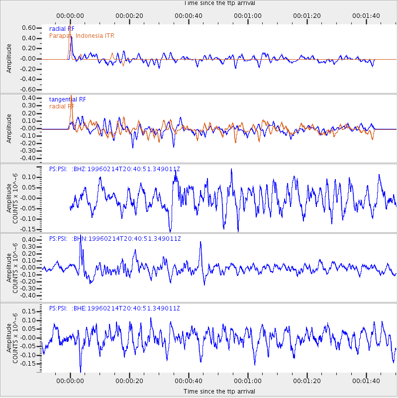
PSI Parapat, Indonesia - Earthquake Result Viewer
*The percent match for this event was below the threshold and hence no stack was calculated.
| Earthquake location: |
Kuril Islands |
| Earthquake latitude/longitude: |
45.4/150.4 |
| Earthquake time(UTC): |
1996/02/14 (045) 20:31:06 GMT |
| Earthquake Depth: |
33 km |
| Earthquake Magnitude: |
5.9 MB, 5.2 MS, 5.8 UNKNOWN, 5.8 MW |
| Earthquake Catalog/Contributor: |
WHDF/NEIC |
|
| Network: |
PS Pacific21 |
| Station: |
PSI Parapat, Indonesia |
| Lat/Lon: |
2.69 N/98.92 E |
| Elevation: |
987 m |
|
| Distance: |
61.8 deg |
| Az: |
242.367 deg |
| Baz: |
38.683 deg |
| Ray Param: |
$rayparam |
*The percent match for this event was below the threshold and hence was not used in the summary stack. |
|
| Radial Match: |
54.304516 % |
| Radial Bump: |
400 |
| Transverse Match: |
62.392235 % |
| Transverse Bump: |
400 |
| SOD ConfigId: |
4480 |
| Insert Time: |
2010-02-27 03:29:58.107 +0000 |
| GWidth: |
2.5 |
| Max Bumps: |
400 |
| Tol: |
0.001 |
|
Signal To Noise
| Channel | StoN | STA | LTA |
| PS:PSI: :BHN:19960214T20:40:51.349011Z | 4.1803327 | 1.4429727E-7 | 3.4518134E-8 |
| PS:PSI: :BHE:19960214T20:40:51.349011Z | 1.7598244 | 6.2783776E-8 | 3.567616E-8 |
| PS:PSI: :BHZ:19960214T20:40:51.349011Z | 1.6626412 | 6.865585E-8 | 4.1293244E-8 |
| Arrivals |
| Ps | |
| PpPs | |
| PsPs/PpSs | |


