You are here: Home > Network List > IU - Global Seismograph Network (GSN - IRIS/USGS) Stations List
> Station MAKZ Makanchi, Kazakhstan > Earthquake Result Viewer
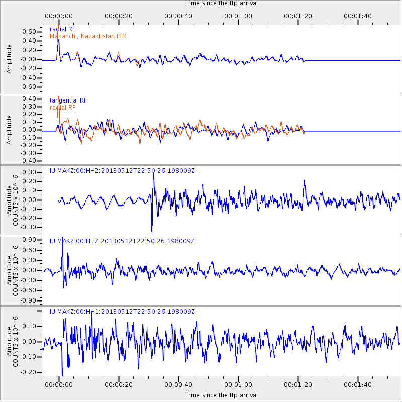
MAKZ Makanchi, Kazakhstan - Earthquake Result Viewer
*The percent match for this event was below the threshold and hence no stack was calculated.
| Earthquake location: |
Kuril Islands |
| Earthquake latitude/longitude: |
44.0/147.8 |
| Earthquake time(UTC): |
2013/05/12 (132) 22:42:45 GMT |
| Earthquake Depth: |
54 km |
| Earthquake Magnitude: |
5.6 MB, 5.2 MW, 5.1 MW |
| Earthquake Catalog/Contributor: |
WHDF/NEIC |
|
| Network: |
IU Global Seismograph Network (GSN - IRIS/USGS) |
| Station: |
MAKZ Makanchi, Kazakhstan |
| Lat/Lon: |
46.81 N/81.98 E |
| Elevation: |
600 m |
|
| Distance: |
45.1 deg |
| Az: |
297.792 deg |
| Baz: |
68.447 deg |
| Ray Param: |
$rayparam |
*The percent match for this event was below the threshold and hence was not used in the summary stack. |
|
| Radial Match: |
57.96878 % |
| Radial Bump: |
400 |
| Transverse Match: |
57.1357 % |
| Transverse Bump: |
400 |
| SOD ConfigId: |
512894 |
| Insert Time: |
2013-09-14 03:17:07.387 +0000 |
| GWidth: |
2.5 |
| Max Bumps: |
400 |
| Tol: |
0.001 |
|
Signal To Noise
| Channel | StoN | STA | LTA |
| IU:MAKZ:00:HHZ:20130512T22:50:26.198009Z | 4.3950424 | 2.759291E-7 | 6.27819E-8 |
| IU:MAKZ:00:HH1:20130512T22:50:26.198009Z | 2.5481768 | 8.411269E-8 | 3.300897E-8 |
| IU:MAKZ:00:HH2:20130512T22:50:26.198009Z | 3.320425 | 1.1985169E-7 | 3.6095287E-8 |
| Arrivals |
| Ps | |
| PpPs | |
| PsPs/PpSs | |


