You are here: Home > Network List > TA - USArray Transportable Network (new EarthScope stations) Stations List
> Station S45A Carrier Mills, IL, USA > Earthquake Result Viewer
S45A Carrier Mills, IL, USA - Earthquake Result Viewer
*The percent match for this event was below the threshold and hence no stack was calculated.
| Earthquake location: |
Kuril Islands |
| Earthquake latitude/longitude: |
44.0/147.8 |
| Earthquake time(UTC): |
2013/05/12 (132) 22:42:45 GMT |
| Earthquake Depth: |
54 km |
| Earthquake Magnitude: |
5.6 MB, 5.2 MW, 5.1 MW |
| Earthquake Catalog/Contributor: |
WHDF/NEIC |
|
| Network: |
TA USArray Transportable Network (new EarthScope stations) |
| Station: |
S45A Carrier Mills, IL, USA |
| Lat/Lon: |
37.68 N/88.58 W |
| Elevation: |
122 m |
|
| Distance: |
84.0 deg |
| Az: |
41.633 deg |
| Baz: |
322.795 deg |
| Ray Param: |
$rayparam |
*The percent match for this event was below the threshold and hence was not used in the summary stack. |
|
| Radial Match: |
57.64415 % |
| Radial Bump: |
400 |
| Transverse Match: |
64.62783 % |
| Transverse Bump: |
400 |
| SOD ConfigId: |
512894 |
| Insert Time: |
2013-09-14 03:33:52.292 +0000 |
| GWidth: |
2.5 |
| Max Bumps: |
400 |
| Tol: |
0.001 |
|
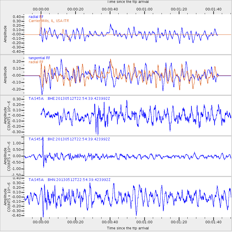
Signal To Noise
| Channel | StoN | STA | LTA |
| TA:S45A: :BHZ:20130512T22:54:39.423992Z | 5.302162 | 3.96812E-7 | 7.483966E-8 |
| TA:S45A: :BHN:20130512T22:54:39.423992Z | 1.8800697 | 1.6053026E-7 | 8.5385274E-8 |
| TA:S45A: :BHE:20130512T22:54:39.423992Z | 1.709228 | 1.1691511E-7 | 6.840229E-8 |
| Arrivals |
| Ps | |
| PpPs | |
| PsPs/PpSs | |


