You are here: Home > Network List > TA - USArray Transportable Network (new EarthScope stations) Stations List
> Station X43A Marvell, AR, USA > Earthquake Result Viewer
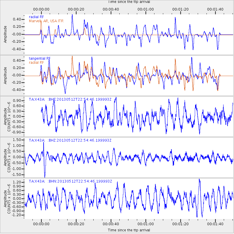
X43A Marvell, AR, USA - Earthquake Result Viewer
*The percent match for this event was below the threshold and hence no stack was calculated.
| Earthquake location: |
Kuril Islands |
| Earthquake latitude/longitude: |
44.0/147.8 |
| Earthquake time(UTC): |
2013/05/12 (132) 22:42:45 GMT |
| Earthquake Depth: |
54 km |
| Earthquake Magnitude: |
5.6 MB, 5.2 MW, 5.1 MW |
| Earthquake Catalog/Contributor: |
WHDF/NEIC |
|
| Network: |
TA USArray Transportable Network (new EarthScope stations) |
| Station: |
X43A Marvell, AR, USA |
| Lat/Lon: |
34.52 N/90.88 W |
| Elevation: |
53 m |
|
| Distance: |
85.4 deg |
| Az: |
45.05 deg |
| Baz: |
321.759 deg |
| Ray Param: |
$rayparam |
*The percent match for this event was below the threshold and hence was not used in the summary stack. |
|
| Radial Match: |
59.274975 % |
| Radial Bump: |
400 |
| Transverse Match: |
53.421593 % |
| Transverse Bump: |
400 |
| SOD ConfigId: |
512894 |
| Insert Time: |
2013-09-14 03:35:57.866 +0000 |
| GWidth: |
2.5 |
| Max Bumps: |
400 |
| Tol: |
0.001 |
|
Signal To Noise
| Channel | StoN | STA | LTA |
| TA:X43A: :BHZ:20130512T22:54:46.199993Z | 1.8395834 | 6.439957E-7 | 3.500769E-7 |
| TA:X43A: :BHN:20130512T22:54:46.199993Z | 1.2356077 | 4.4494067E-7 | 3.6009862E-7 |
| TA:X43A: :BHE:20130512T22:54:46.199993Z | 1.0199751 | 4.0442472E-7 | 3.9650453E-7 |
| Arrivals |
| Ps | |
| PpPs | |
| PsPs/PpSs | |


