You are here: Home > Network List > US - United States National Seismic Network Stations List
> Station CBKS Cedar Bluff, Kansas, USA > Earthquake Result Viewer
CBKS Cedar Bluff, Kansas, USA - Earthquake Result Viewer
*The percent match for this event was below the threshold and hence no stack was calculated.
| Earthquake location: |
Kuril Islands |
| Earthquake latitude/longitude: |
44.0/147.8 |
| Earthquake time(UTC): |
2013/05/12 (132) 22:42:45 GMT |
| Earthquake Depth: |
54 km |
| Earthquake Magnitude: |
5.6 MB, 5.2 MW, 5.1 MW |
| Earthquake Catalog/Contributor: |
WHDF/NEIC |
|
| Network: |
US United States National Seismic Network |
| Station: |
CBKS Cedar Bluff, Kansas, USA |
| Lat/Lon: |
38.81 N/99.74 W |
| Elevation: |
677 m |
|
| Distance: |
77.5 deg |
| Az: |
47.688 deg |
| Baz: |
316.876 deg |
| Ray Param: |
$rayparam |
*The percent match for this event was below the threshold and hence was not used in the summary stack. |
|
| Radial Match: |
60.125183 % |
| Radial Bump: |
400 |
| Transverse Match: |
62.1759 % |
| Transverse Bump: |
400 |
| SOD ConfigId: |
512894 |
| Insert Time: |
2013-09-14 03:37:45.778 +0000 |
| GWidth: |
2.5 |
| Max Bumps: |
400 |
| Tol: |
0.001 |
|
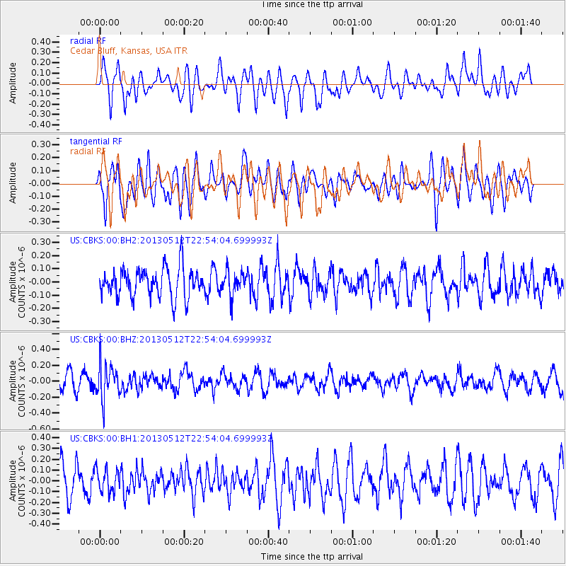
Signal To Noise
| Channel | StoN | STA | LTA |
| US:CBKS:00:BHZ:20130512T22:54:04.699993Z | 2.345188 | 2.1616913E-7 | 9.217561E-8 |
| US:CBKS:00:BH1:20130512T22:54:04.699993Z | 0.6869531 | 1.04971065E-7 | 1.5280673E-7 |
| US:CBKS:00:BH2:20130512T22:54:04.699993Z | 0.79546505 | 8.705214E-8 | 1.0943553E-7 |
| Arrivals |
| Ps | |
| PpPs | |
| PsPs/PpSs | |


