You are here: Home > Network List > US - United States National Seismic Network Stations List
> Station WMOK Wichita Mountains, Oklahoma, USA > Earthquake Result Viewer
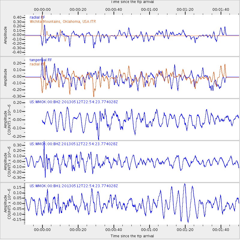
WMOK Wichita Mountains, Oklahoma, USA - Earthquake Result Viewer
*The percent match for this event was below the threshold and hence no stack was calculated.
| Earthquake location: |
Kuril Islands |
| Earthquake latitude/longitude: |
44.0/147.8 |
| Earthquake time(UTC): |
2013/05/12 (132) 22:42:45 GMT |
| Earthquake Depth: |
54 km |
| Earthquake Magnitude: |
5.6 MB, 5.2 MW, 5.1 MW |
| Earthquake Catalog/Contributor: |
WHDF/NEIC |
|
| Network: |
US United States National Seismic Network |
| Station: |
WMOK Wichita Mountains, Oklahoma, USA |
| Lat/Lon: |
34.74 N/98.78 W |
| Elevation: |
486 m |
|
| Distance: |
81.0 deg |
| Az: |
49.917 deg |
| Baz: |
317.862 deg |
| Ray Param: |
$rayparam |
*The percent match for this event was below the threshold and hence was not used in the summary stack. |
|
| Radial Match: |
49.27983 % |
| Radial Bump: |
400 |
| Transverse Match: |
59.954308 % |
| Transverse Bump: |
400 |
| SOD ConfigId: |
512894 |
| Insert Time: |
2013-09-14 03:39:30.373 +0000 |
| GWidth: |
2.5 |
| Max Bumps: |
400 |
| Tol: |
0.001 |
|
Signal To Noise
| Channel | StoN | STA | LTA |
| US:WMOK:00:BHZ:20130512T22:54:23.774028Z | 2.0203512 | 1.247412E-7 | 6.1742334E-8 |
| US:WMOK:00:BH1:20130512T22:54:23.774028Z | 1.6991376 | 7.078147E-8 | 4.165729E-8 |
| US:WMOK:00:BH2:20130512T22:54:23.774028Z | 1.2094921 | 9.290532E-8 | 7.681349E-8 |
| Arrivals |
| Ps | |
| PpPs | |
| PsPs/PpSs | |


