You are here: Home > Network List > WY - Yellowstone Wyoming Seismic Network Stations List
> Station YHH Holmes Hill, YNP, WY, USA > Earthquake Result Viewer
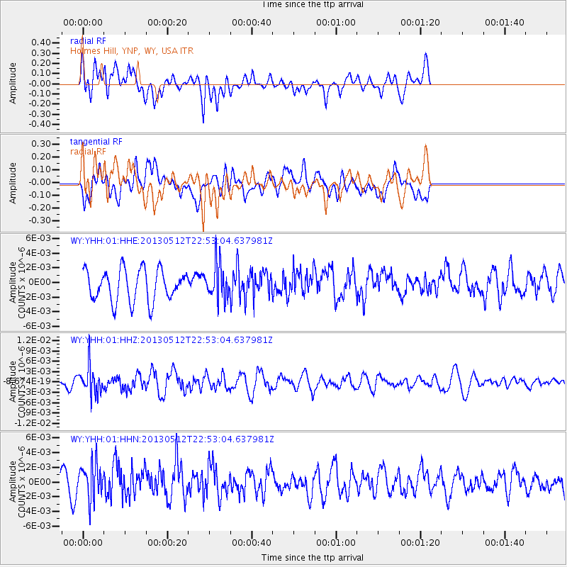
YHH Holmes Hill, YNP, WY, USA - Earthquake Result Viewer
*The percent match for this event was below the threshold and hence no stack was calculated.
| Earthquake location: |
Kuril Islands |
| Earthquake latitude/longitude: |
44.0/147.8 |
| Earthquake time(UTC): |
2013/05/12 (132) 22:42:45 GMT |
| Earthquake Depth: |
54 km |
| Earthquake Magnitude: |
5.6 MB, 5.2 MW, 5.1 MW |
| Earthquake Catalog/Contributor: |
WHDF/NEIC |
|
| Network: |
WY Yellowstone Wyoming Seismic Network |
| Station: |
YHH Holmes Hill, YNP, WY, USA |
| Lat/Lon: |
44.79 N/110.85 W |
| Elevation: |
2717 m |
|
| Distance: |
67.4 deg |
| Az: |
49.14 deg |
| Baz: |
309.913 deg |
| Ray Param: |
$rayparam |
*The percent match for this event was below the threshold and hence was not used in the summary stack. |
|
| Radial Match: |
71.15339 % |
| Radial Bump: |
400 |
| Transverse Match: |
60.208263 % |
| Transverse Bump: |
400 |
| SOD ConfigId: |
512894 |
| Insert Time: |
2013-09-14 03:42:46.802 +0000 |
| GWidth: |
2.5 |
| Max Bumps: |
400 |
| Tol: |
0.001 |
|
Signal To Noise
| Channel | StoN | STA | LTA |
| WY:YHH:01:HHZ:20130512T22:53:04.637981Z | 2.4388137 | 3.994881E-9 | 1.6380427E-9 |
| WY:YHH:01:HHN:20130512T22:53:04.637981Z | 2.5081158 | 2.4915017E-9 | 9.933758E-10 |
| WY:YHH:01:HHE:20130512T22:53:04.637981Z | 1.1204855 | 2.427938E-9 | 2.1668625E-9 |
| Arrivals |
| Ps | |
| PpPs | |
| PsPs/PpSs | |


