You are here: Home > Network List > II - Global Seismograph Network (GSN - IRIS/IDA) Stations List
> Station WRAB Tennant Creek, NT, Australia > Earthquake Result Viewer
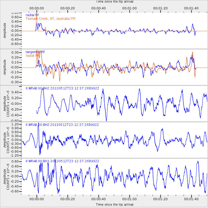
WRAB Tennant Creek, NT, Australia - Earthquake Result Viewer
*The percent match for this event was below the threshold and hence no stack was calculated.
| Earthquake location: |
Mariana Islands Region |
| Earthquake latitude/longitude: |
21.9/143.7 |
| Earthquake time(UTC): |
2013/05/12 (132) 23:05:27 GMT |
| Earthquake Depth: |
167 km |
| Earthquake Magnitude: |
5.5 MW, 5.1 MB, 5.6 MW |
| Earthquake Catalog/Contributor: |
WHDF/NEIC |
|
| Network: |
II Global Seismograph Network (GSN - IRIS/IDA) |
| Station: |
WRAB Tennant Creek, NT, Australia |
| Lat/Lon: |
19.93 S/134.36 E |
| Elevation: |
366 m |
|
| Distance: |
42.6 deg |
| Az: |
193.094 deg |
| Baz: |
12.919 deg |
| Ray Param: |
$rayparam |
*The percent match for this event was below the threshold and hence was not used in the summary stack. |
|
| Radial Match: |
53.845314 % |
| Radial Bump: |
400 |
| Transverse Match: |
54.520603 % |
| Transverse Bump: |
400 |
| SOD ConfigId: |
512894 |
| Insert Time: |
2013-09-14 03:54:40.385 +0000 |
| GWidth: |
2.5 |
| Max Bumps: |
400 |
| Tol: |
0.001 |
|
Signal To Noise
| Channel | StoN | STA | LTA |
| II:WRAB:00:BHZ:20130512T23:12:37.268992Z | 3.0320883 | 6.3815844E-7 | 2.104683E-7 |
| II:WRAB:00:BH1:20130512T23:12:37.268992Z | 1.3360862 | 3.3596532E-7 | 2.5145485E-7 |
| II:WRAB:00:BH2:20130512T23:12:37.268992Z | 0.4112791 | 9.360887E-8 | 2.2760425E-7 |
| Arrivals |
| Ps | |
| PpPs | |
| PsPs/PpSs | |


