You are here: Home > Network List > AT - Alaska Tsunami Warning Seismic System Stations List
> Station SVW2 Sparrevohn, Alaska > Earthquake Result Viewer
SVW2 Sparrevohn, Alaska - Earthquake Result Viewer
| Earthquake location: |
Mariana Islands |
| Earthquake latitude/longitude: |
18.7/145.3 |
| Earthquake time(UTC): |
2013/05/14 (134) 00:32:25 GMT |
| Earthquake Depth: |
602 km |
| Earthquake Magnitude: |
6.8 MW, 6.2 MB, 6.8 MW |
| Earthquake Catalog/Contributor: |
NEIC PDE/NEIC PDE-W |
|
| Network: |
AT Alaska Tsunami Warning Seismic System |
| Station: |
SVW2 Sparrevohn, Alaska |
| Lat/Lon: |
61.11 N/155.62 W |
| Elevation: |
499 m |
|
| Distance: |
59.0 deg |
| Az: |
29.093 deg |
| Baz: |
251.595 deg |
| Ray Param: |
0.060019992 |
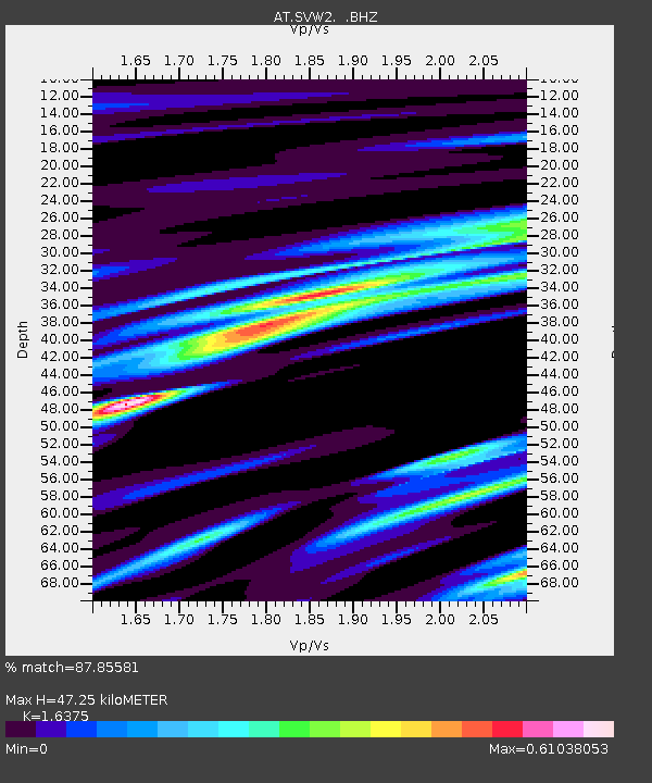
| Estimated Moho Depth: |
47.25 km |
| Estimated Crust Vp/Vs: |
1.64 |
| Assumed Crust Vp: |
6.566 km/s |
| Estimated Crust Vs: |
4.01 km/s |
| Estimated Crust Poisson's Ratio: |
0.20 |
|
| Radial Match: |
87.85581 % |
| Radial Bump: |
319 |
| Transverse Match: |
66.68418 % |
| Transverse Bump: |
400 |
| SOD ConfigId: |
512894 |
| Insert Time: |
2013-09-14 04:10:18.075 +0000 |
| GWidth: |
2.5 |
| Max Bumps: |
400 |
| Tol: |
0.001 |
|

Signal To Noise
| Channel | StoN | STA | LTA |
| AT:SVW2: :BHZ:20130514T00:40:58.100022Z | 58.594215 | 6.3557395E-6 | 1.0847043E-7 |
| AT:SVW2: :BHN:20130514T00:40:58.100022Z | 13.340077 | 1.3517616E-6 | 1.0133086E-7 |
| AT:SVW2: :BHE:20130514T00:40:58.100022Z | 27.077185 | 2.4821268E-6 | 9.166857E-8 |
| Arrivals |
| Ps | 4.8 SECOND |
| PpPs | 18 SECOND |
| PsPs/PpSs | 23 SECOND |


