You are here: Home > Network List > AU - Australian Seismological Centre Stations List
> Station PSAA2 Pilbara Seismic Array Element A2 > Earthquake Result Viewer
PSAA2 Pilbara Seismic Array Element A2 - Earthquake Result Viewer
| Earthquake location: |
Mariana Islands |
| Earthquake latitude/longitude: |
18.7/145.3 |
| Earthquake time(UTC): |
2013/05/14 (134) 00:32:25 GMT |
| Earthquake Depth: |
602 km |
| Earthquake Magnitude: |
6.8 MW, 6.2 MB, 6.8 MW |
| Earthquake Catalog/Contributor: |
NEIC PDE/NEIC PDE-W |
|
| Network: |
AU Australian Seismological Centre |
| Station: |
PSAA2 Pilbara Seismic Array Element A2 |
| Lat/Lon: |
21.56 S/119.85 E |
| Elevation: |
330 m |
|
| Distance: |
47.2 deg |
| Az: |
213.052 deg |
| Baz: |
33.729 deg |
| Ray Param: |
0.06724928 |
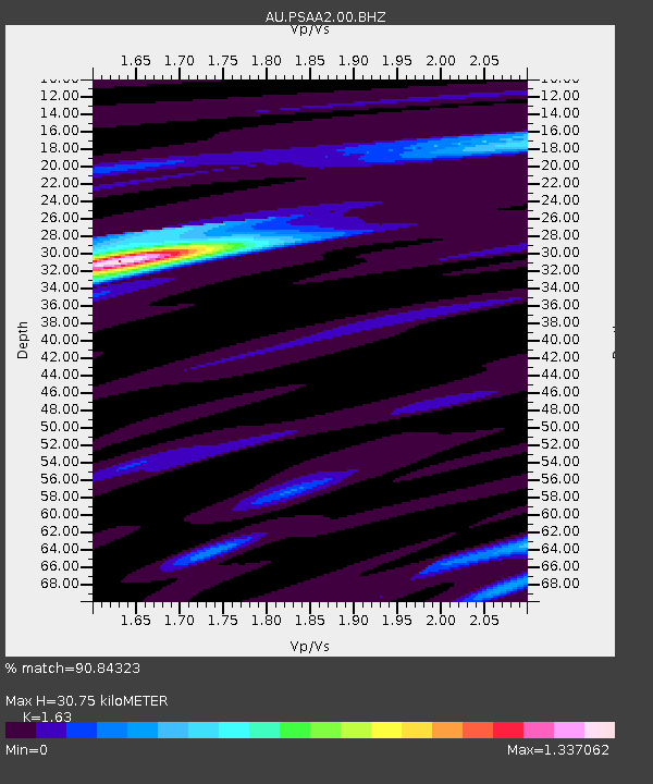
| Estimated Moho Depth: |
30.75 km |
| Estimated Crust Vp/Vs: |
1.63 |
| Assumed Crust Vp: |
6.464 km/s |
| Estimated Crust Vs: |
3.965 km/s |
| Estimated Crust Poisson's Ratio: |
0.20 |
|
| Radial Match: |
90.84323 % |
| Radial Bump: |
392 |
| Transverse Match: |
66.30891 % |
| Transverse Bump: |
400 |
| SOD ConfigId: |
512894 |
| Insert Time: |
2013-09-14 04:11:27.644 +0000 |
| GWidth: |
2.5 |
| Max Bumps: |
400 |
| Tol: |
0.001 |
|

Signal To Noise
| Channel | StoN | STA | LTA |
| AU:PSAA2:00:BHZ:20130514T00:39:34.693986Z | 12.116098 | 7.890568E-6 | 6.512466E-7 |
| AU:PSAA2:00:BH1:20130514T00:39:34.693986Z | 4.78213 | 1.9385216E-6 | 4.0536787E-7 |
| AU:PSAA2:00:BH2:20130514T00:39:34.693986Z | 10.9598255 | 3.6703973E-6 | 3.348956E-7 |
| Arrivals |
| Ps | 3.2 SECOND |
| PpPs | 12 SECOND |
| PsPs/PpSs | 15 SECOND |


