You are here: Home > Network List > AU - Australian Seismological Centre Stations List
> Station PSAB2 Pilbara Seismic Array Element B2 > Earthquake Result Viewer
PSAB2 Pilbara Seismic Array Element B2 - Earthquake Result Viewer
| Earthquake location: |
Mariana Islands |
| Earthquake latitude/longitude: |
18.7/145.3 |
| Earthquake time(UTC): |
2013/05/14 (134) 00:32:25 GMT |
| Earthquake Depth: |
602 km |
| Earthquake Magnitude: |
6.8 MW, 6.2 MB, 6.8 MW |
| Earthquake Catalog/Contributor: |
NEIC PDE/NEIC PDE-W |
|
| Network: |
AU Australian Seismological Centre |
| Station: |
PSAB2 Pilbara Seismic Array Element B2 |
| Lat/Lon: |
21.55 S/119.86 E |
| Elevation: |
302 m |
|
| Distance: |
47.1 deg |
| Az: |
213.042 deg |
| Baz: |
33.718 deg |
| Ray Param: |
0.06725793 |
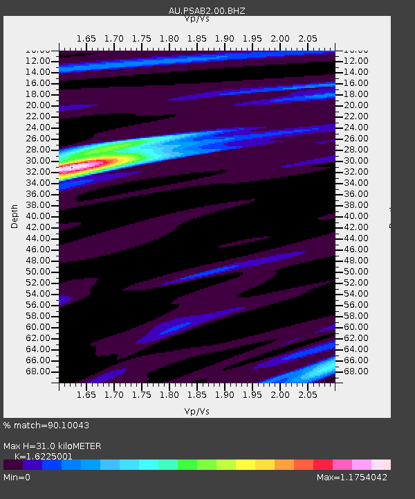
| Estimated Moho Depth: |
31.0 km |
| Estimated Crust Vp/Vs: |
1.62 |
| Assumed Crust Vp: |
6.464 km/s |
| Estimated Crust Vs: |
3.984 km/s |
| Estimated Crust Poisson's Ratio: |
0.19 |
|
| Radial Match: |
90.10043 % |
| Radial Bump: |
327 |
| Transverse Match: |
57.896954 % |
| Transverse Bump: |
400 |
| SOD ConfigId: |
512894 |
| Insert Time: |
2013-09-14 04:11:34.621 +0000 |
| GWidth: |
2.5 |
| Max Bumps: |
400 |
| Tol: |
0.001 |
|

Signal To Noise
| Channel | StoN | STA | LTA |
| AU:PSAB2:00:BHZ:20130514T00:39:34.59401Z | 12.1459465 | 7.920447E-6 | 6.521062E-7 |
| AU:PSAB2:00:BH1:20130514T00:39:34.59401Z | 12.328708 | 4.246919E-6 | 3.44474E-7 |
| AU:PSAB2:00:BH2:20130514T00:39:34.59401Z | 2.1143782 | 9.382718E-7 | 4.4375778E-7 |
| Arrivals |
| Ps | 3.2 SECOND |
| PpPs | 12 SECOND |
| PsPs/PpSs | 15 SECOND |


