You are here: Home > Network List > AU - Australian Seismological Centre Stations List
> Station WB2 Warramunga Array, NT > Earthquake Result Viewer
WB2 Warramunga Array, NT - Earthquake Result Viewer
| Earthquake location: |
Mariana Islands |
| Earthquake latitude/longitude: |
18.7/145.3 |
| Earthquake time(UTC): |
2013/05/14 (134) 00:32:25 GMT |
| Earthquake Depth: |
602 km |
| Earthquake Magnitude: |
6.8 MW, 6.2 MB, 6.8 MW |
| Earthquake Catalog/Contributor: |
NEIC PDE/NEIC PDE-W |
|
| Network: |
AU Australian Seismological Centre |
| Station: |
WB2 Warramunga Array, NT |
| Lat/Lon: |
19.94 S/134.35 E |
| Elevation: |
425 m |
|
| Distance: |
39.9 deg |
| Az: |
196.156 deg |
| Baz: |
16.279 deg |
| Ray Param: |
0.07157842 |
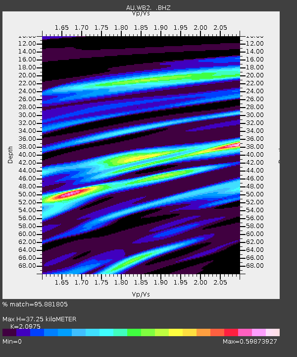
| Estimated Moho Depth: |
37.25 km |
| Estimated Crust Vp/Vs: |
2.10 |
| Assumed Crust Vp: |
6.642 km/s |
| Estimated Crust Vs: |
3.167 km/s |
| Estimated Crust Poisson's Ratio: |
0.35 |
|
| Radial Match: |
95.881805 % |
| Radial Bump: |
344 |
| Transverse Match: |
83.205605 % |
| Transverse Bump: |
400 |
| SOD ConfigId: |
512894 |
| Insert Time: |
2013-09-14 04:12:05.210 +0000 |
| GWidth: |
2.5 |
| Max Bumps: |
400 |
| Tol: |
0.001 |
|

Signal To Noise
| Channel | StoN | STA | LTA |
| AU:WB2: :BHZ:20130514T00:38:38.798997Z | 33.377594 | 8.684977E-6 | 2.602038E-7 |
| AU:WB2: :BHN:20130514T00:38:38.798997Z | 23.979961 | 5.0503945E-6 | 2.1060895E-7 |
| AU:WB2: :BHE:20130514T00:38:38.798997Z | 4.7807465 | 8.7500115E-7 | 1.8302605E-7 |
| Arrivals |
| Ps | 6.5 SECOND |
| PpPs | 16 SECOND |
| PsPs/PpSs | 23 SECOND |


