You are here: Home > Network List > CB - China National Seismic Network Stations List
> Station GOM Geermu,Qinghai Province > Earthquake Result Viewer
GOM Geermu,Qinghai Province - Earthquake Result Viewer
| Earthquake location: |
Mariana Islands |
| Earthquake latitude/longitude: |
18.7/145.3 |
| Earthquake time(UTC): |
2013/05/14 (134) 00:32:25 GMT |
| Earthquake Depth: |
602 km |
| Earthquake Magnitude: |
6.8 MW, 6.2 MB, 6.8 MW |
| Earthquake Catalog/Contributor: |
NEIC PDE/NEIC PDE-W |
|
| Network: |
CB China National Seismic Network |
| Station: |
GOM Geermu,Qinghai Province |
| Lat/Lon: |
36.20 N/94.81 E |
| Elevation: |
3121 m |
|
| Distance: |
47.5 deg |
| Az: |
302.204 deg |
| Baz: |
97.521 deg |
| Ray Param: |
0.067033365 |
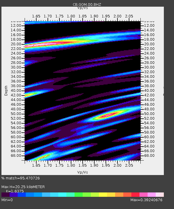
| Estimated Moho Depth: |
20.25 km |
| Estimated Crust Vp/Vs: |
1.64 |
| Assumed Crust Vp: |
6.385 km/s |
| Estimated Crust Vs: |
3.899 km/s |
| Estimated Crust Poisson's Ratio: |
0.20 |
|
| Radial Match: |
95.470726 % |
| Radial Bump: |
306 |
| Transverse Match: |
84.13425 % |
| Transverse Bump: |
400 |
| SOD ConfigId: |
512894 |
| Insert Time: |
2013-09-14 04:14:20.350 +0000 |
| GWidth: |
2.5 |
| Max Bumps: |
400 |
| Tol: |
0.001 |
|

Signal To Noise
| Channel | StoN | STA | LTA |
| CB:GOM:00:BHZ:20130514T00:39:37.300004Z | 19.207901 | 2.407376E-6 | 1.2533259E-7 |
| CB:GOM:00:BHN:20130514T00:39:37.300004Z | 6.5685043 | 2.894389E-7 | 4.406466E-8 |
| CB:GOM:00:BHE:20130514T00:39:37.300004Z | 11.408364 | 5.2564064E-7 | 4.6075026E-8 |
| Arrivals |
| Ps | 2.1 SECOND |
| PpPs | 7.9 SECOND |
| PsPs/PpSs | 10 SECOND |


