You are here: Home > Network List > GO - National Seismic Network of Georgia Stations List
> Station ONI Oni, Georgia > Earthquake Result Viewer
ONI Oni, Georgia - Earthquake Result Viewer

| Earthquake location: |
Mariana Islands |
| Earthquake latitude/longitude: |
18.7/145.3 |
| Earthquake time(UTC): |
2013/05/14 (134) 00:32:25 GMT |
| Earthquake Depth: |
602 km |
| Earthquake Magnitude: |
6.8 MW, 6.2 MB, 6.8 MW |
| Earthquake Catalog/Contributor: |
NEIC PDE/NEIC PDE-W |
|
| Network: |
GO National Seismic Network of Georgia |
| Station: |
ONI Oni, Georgia |
| Lat/Lon: |
42.59 N/43.45 E |
| Elevation: |
0.0 m |
|
| Distance: |
85.9 deg |
| Az: |
313.562 deg |
| Baz: |
68.427 deg |
| Ray Param: |
0.04268714 |
| Estimated Moho Depth: |
16.75 km |
| Estimated Crust Vp/Vs: |
1.87 |
| Assumed Crust Vp: |
6.247 km/s |
| Estimated Crust Vs: |
3.34 km/s |
| Estimated Crust Poisson's Ratio: |
0.30 |
|
| Radial Match: |
80.342865 % |
| Radial Bump: |
400 |
| Transverse Match: |
80.13845 % |
| Transverse Bump: |
400 |
| SOD ConfigId: |
512894 |
| Insert Time: |
2013-09-14 04:19:45.857 +0000 |
| GWidth: |
2.5 |
| Max Bumps: |
400 |
| Tol: |
0.001 |
|
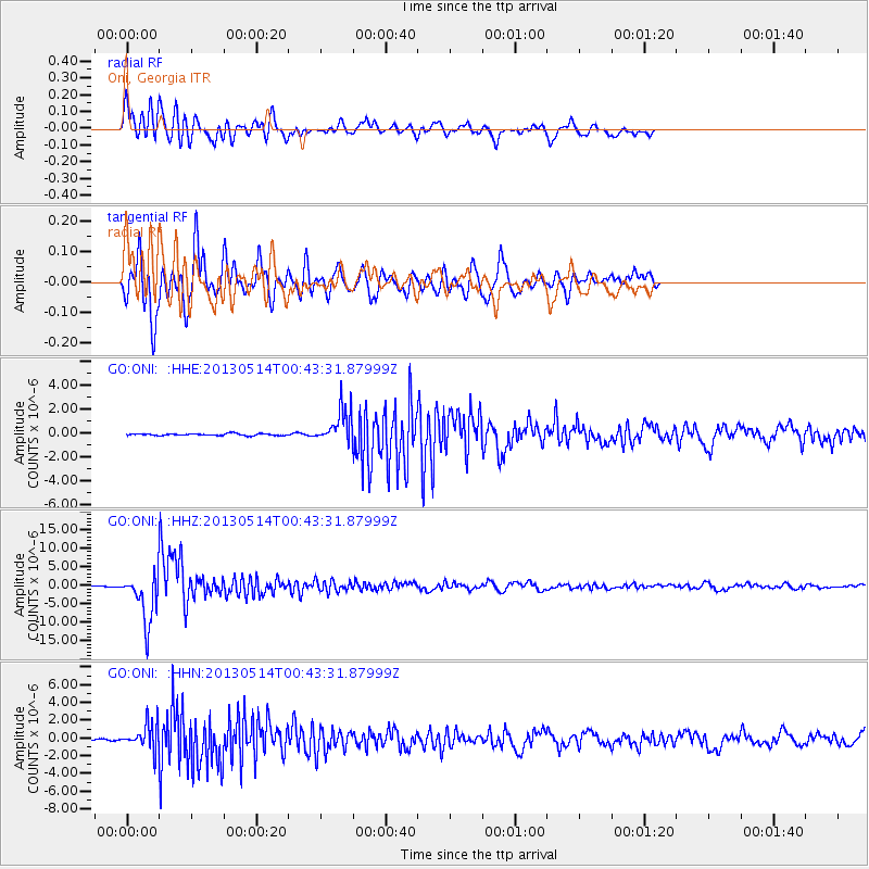
Signal To Noise
| Channel | StoN | STA | LTA |
| GO:ONI: :HHZ:20130514T00:43:31.87999Z | 62.341194 | 6.5720574E-6 | 1.0542078E-7 |
| GO:ONI: :HHN:20130514T00:43:31.87999Z | 14.940964 | 1.4233135E-6 | 9.526249E-8 |
| GO:ONI: :HHE:20130514T00:43:31.87999Z | 18.202198 | 1.433447E-6 | 7.8751306E-8 |
| Arrivals |
| Ps | 2.4 SECOND |
| PpPs | 7.5 SECOND |
| PsPs/PpSs | 9.9 SECOND |


