You are here: Home > Network List > IU - Global Seismograph Network (GSN - IRIS/USGS) Stations List
> Station GNI Garni, Armenia > Earthquake Result Viewer
GNI Garni, Armenia - Earthquake Result Viewer
| Earthquake location: |
Mariana Islands |
| Earthquake latitude/longitude: |
18.7/145.3 |
| Earthquake time(UTC): |
2013/05/14 (134) 00:32:25 GMT |
| Earthquake Depth: |
602 km |
| Earthquake Magnitude: |
6.8 MW, 6.2 MB, 6.8 MW |
| Earthquake Catalog/Contributor: |
NEIC PDE/NEIC PDE-W |
|
| Network: |
IU Global Seismograph Network (GSN - IRIS/USGS) |
| Station: |
GNI Garni, Armenia |
| Lat/Lon: |
40.15 N/44.74 E |
| Elevation: |
1609 m |
|
| Distance: |
85.9 deg |
| Az: |
310.929 deg |
| Baz: |
69.086 deg |
| Ray Param: |
0.042701192 |
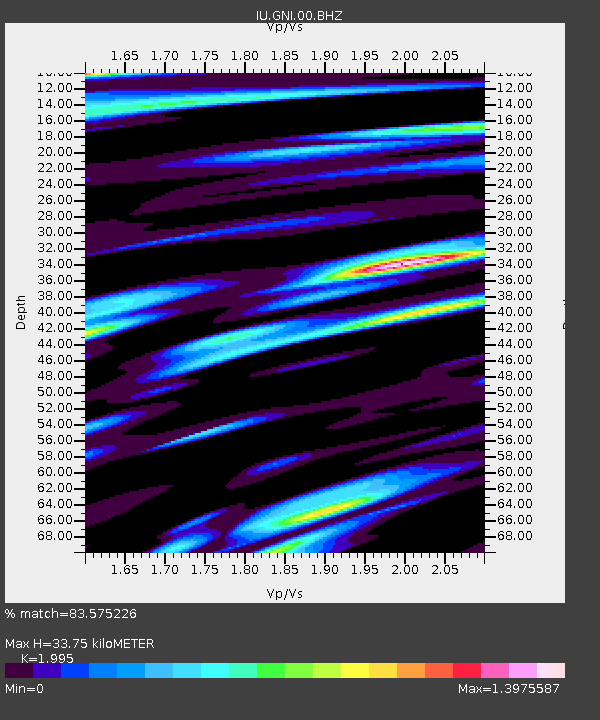
| Estimated Moho Depth: |
33.75 km |
| Estimated Crust Vp/Vs: |
2.00 |
| Assumed Crust Vp: |
6.291 km/s |
| Estimated Crust Vs: |
3.153 km/s |
| Estimated Crust Poisson's Ratio: |
0.33 |
|
| Radial Match: |
83.575226 % |
| Radial Bump: |
400 |
| Transverse Match: |
81.03894 % |
| Transverse Bump: |
400 |
| SOD ConfigId: |
512894 |
| Insert Time: |
2013-09-14 04:22:21.869 +0000 |
| GWidth: |
2.5 |
| Max Bumps: |
400 |
| Tol: |
0.001 |
|
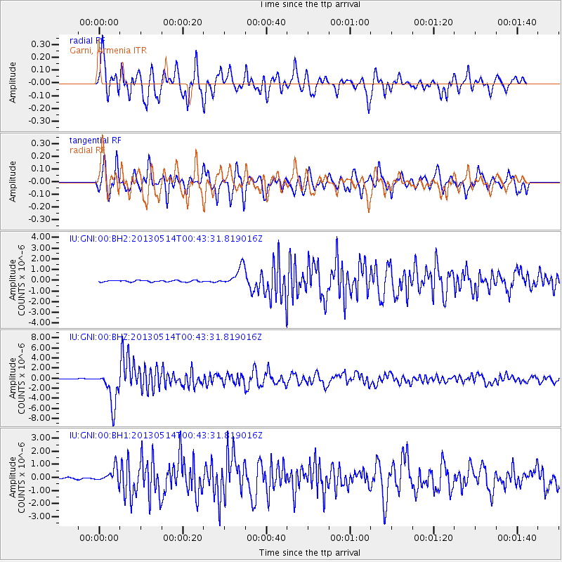
Signal To Noise
| Channel | StoN | STA | LTA |
| IU:GNI:00:BHZ:20130514T00:43:31.819016Z | 55.607437 | 3.5369096E-6 | 6.360497E-8 |
| IU:GNI:00:BH1:20130514T00:43:31.819016Z | 8.94128 | 5.867846E-7 | 6.5626466E-8 |
| IU:GNI:00:BH2:20130514T00:43:31.819016Z | 13.0894575 | 9.251748E-7 | 7.068091E-8 |
| Arrivals |
| Ps | 5.4 SECOND |
| PpPs | 16 SECOND |
| PsPs/PpSs | 21 SECOND |


