You are here: Home > Network List > KR - Kyrgyz Digital Network Stations List
> Station NRN Naryn, Kyrgyzstan > Earthquake Result Viewer
NRN Naryn, Kyrgyzstan - Earthquake Result Viewer
| Earthquake location: |
Mariana Islands |
| Earthquake latitude/longitude: |
18.7/145.3 |
| Earthquake time(UTC): |
2013/05/14 (134) 00:32:25 GMT |
| Earthquake Depth: |
602 km |
| Earthquake Magnitude: |
6.8 MW, 6.2 MB, 6.8 MW |
| Earthquake Catalog/Contributor: |
NEIC PDE/NEIC PDE-W |
|
| Network: |
KR Kyrgyz Digital Network |
| Station: |
NRN Naryn, Kyrgyzstan |
| Lat/Lon: |
41.42 N/75.98 E |
| Elevation: |
2120 m |
|
| Distance: |
62.5 deg |
| Az: |
307.496 deg |
| Baz: |
88.751 deg |
| Ray Param: |
0.05786835 |
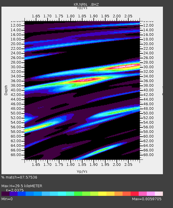
| Estimated Moho Depth: |
29.5 km |
| Estimated Crust Vp/Vs: |
2.04 |
| Assumed Crust Vp: |
6.491 km/s |
| Estimated Crust Vs: |
3.186 km/s |
| Estimated Crust Poisson's Ratio: |
0.34 |
|
| Radial Match: |
87.57536 % |
| Radial Bump: |
400 |
| Transverse Match: |
86.76981 % |
| Transverse Bump: |
400 |
| SOD ConfigId: |
512894 |
| Insert Time: |
2013-09-14 04:24:45.295 +0000 |
| GWidth: |
2.5 |
| Max Bumps: |
400 |
| Tol: |
0.001 |
|

Signal To Noise
| Channel | StoN | STA | LTA |
| KR:NRN: :BHZ:20130514T00:41:20.949998Z | 77.823555 | 3.820886E-6 | 4.909678E-8 |
| KR:NRN: :BHN:20130514T00:41:20.949998Z | 21.038765 | 9.0051935E-7 | 4.2802863E-8 |
| KR:NRN: :BHE:20130514T00:41:20.949998Z | 44.423733 | 1.5350173E-6 | 3.4553995E-8 |
| Arrivals |
| Ps | 4.9 SECOND |
| PpPs | 13 SECOND |
| PsPs/PpSs | 18 SECOND |


