You are here: Home > Network List > TA - USArray Transportable Network (new EarthScope stations) Stations List
> Station K02D Willamette Meridian, OR, USA > Earthquake Result Viewer
K02D Willamette Meridian, OR, USA - Earthquake Result Viewer
| Earthquake location: |
Mariana Islands |
| Earthquake latitude/longitude: |
18.7/145.3 |
| Earthquake time(UTC): |
2013/05/14 (134) 00:32:25 GMT |
| Earthquake Depth: |
602 km |
| Earthquake Magnitude: |
6.8 MW, 6.2 MB, 6.8 MW |
| Earthquake Catalog/Contributor: |
NEIC PDE/NEIC PDE-W |
|
| Network: |
TA USArray Transportable Network (new EarthScope stations) |
| Station: |
K02D Willamette Meridian, OR, USA |
| Lat/Lon: |
42.70 N/123.67 W |
| Elevation: |
989 m |
|
| Distance: |
78.3 deg |
| Az: |
48.83 deg |
| Baz: |
284.609 deg |
| Ray Param: |
0.047845513 |
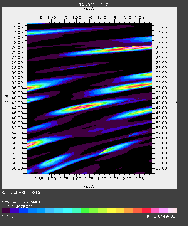
| Estimated Moho Depth: |
58.5 km |
| Estimated Crust Vp/Vs: |
1.60 |
| Assumed Crust Vp: |
6.522 km/s |
| Estimated Crust Vs: |
4.07 km/s |
| Estimated Crust Poisson's Ratio: |
0.18 |
|
| Radial Match: |
89.70315 % |
| Radial Bump: |
400 |
| Transverse Match: |
92.23672 % |
| Transverse Bump: |
400 |
| SOD ConfigId: |
512894 |
| Insert Time: |
2013-09-14 04:30:37.813 +0000 |
| GWidth: |
2.5 |
| Max Bumps: |
400 |
| Tol: |
0.001 |
|
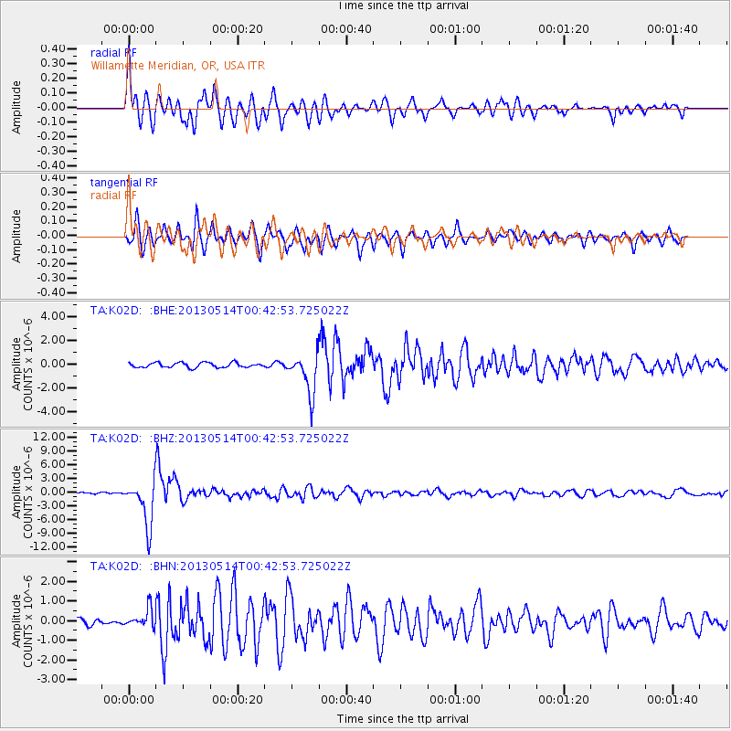
Signal To Noise
| Channel | StoN | STA | LTA |
| TA:K02D: :BHZ:20130514T00:42:53.725022Z | 32.618317 | 4.9467485E-6 | 1.5165556E-7 |
| TA:K02D: :BHN:20130514T00:42:53.725022Z | 3.0684373 | 4.8790776E-7 | 1.5900855E-7 |
| TA:K02D: :BHE:20130514T00:42:53.725022Z | 8.354606 | 1.698527E-6 | 2.0330427E-7 |
| Arrivals |
| Ps | 5.6 SECOND |
| PpPs | 23 SECOND |
| PsPs/PpSs | 28 SECOND |


