You are here: Home > Network List > UU - University of Utah Regional Network Stations List
> Station CVRU Castle Valley Ranch, Emery, UT, USA old TA-Q16A > Earthquake Result Viewer
CVRU Castle Valley Ranch, Emery, UT, USA old TA-Q16A - Earthquake Result Viewer
| Earthquake location: |
Mariana Islands |
| Earthquake latitude/longitude: |
18.7/145.3 |
| Earthquake time(UTC): |
2013/05/14 (134) 00:32:25 GMT |
| Earthquake Depth: |
602 km |
| Earthquake Magnitude: |
6.8 MW, 6.2 MB, 6.8 MW |
| Earthquake Catalog/Contributor: |
NEIC PDE/NEIC PDE-W |
|
| Network: |
UU University of Utah Regional Network |
| Station: |
CVRU Castle Valley Ranch, Emery, UT, USA old TA-Q16A |
| Lat/Lon: |
38.92 N/111.17 W |
| Elevation: |
1912 m |
|
| Distance: |
88.5 deg |
| Az: |
49.349 deg |
| Baz: |
292.826 deg |
| Ray Param: |
0.04164621 |
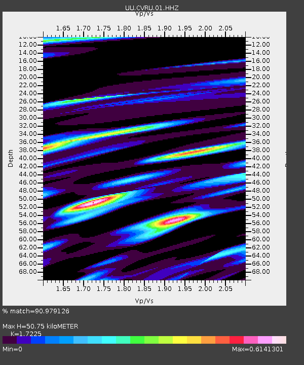
| Estimated Moho Depth: |
50.75 km |
| Estimated Crust Vp/Vs: |
1.72 |
| Assumed Crust Vp: |
6.207 km/s |
| Estimated Crust Vs: |
3.603 km/s |
| Estimated Crust Poisson's Ratio: |
0.25 |
|
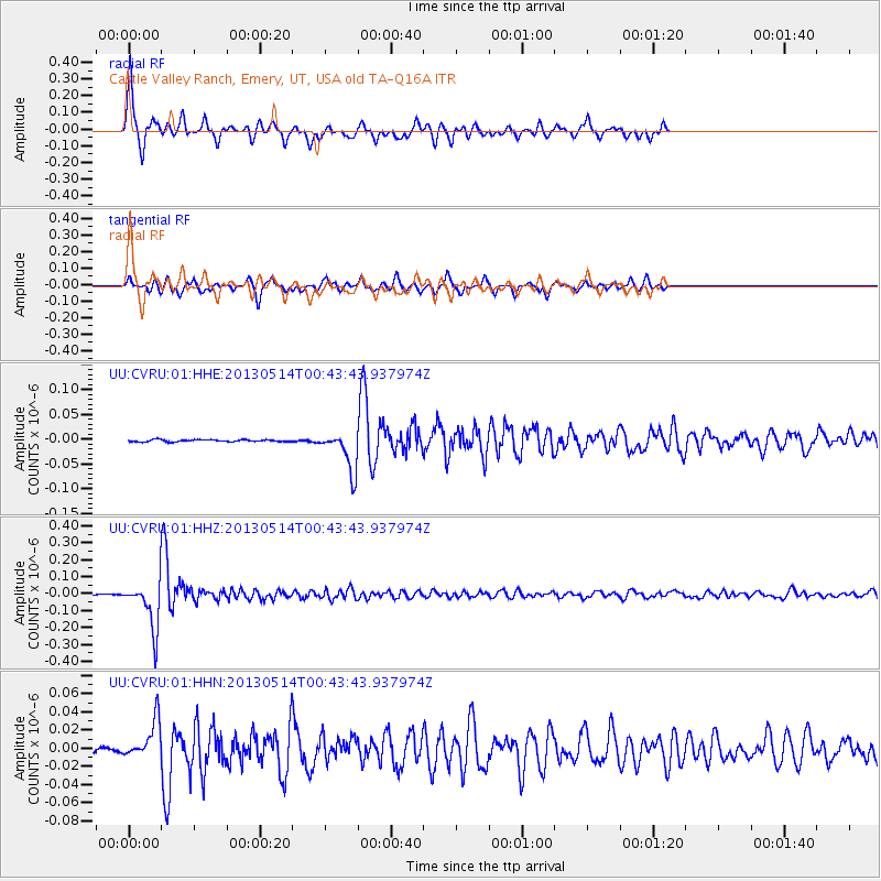
| Radial Match: |
90.979126 % |
| Radial Bump: |
307 |
| Transverse Match: |
76.54422 % |
| Transverse Bump: |
308 |
| SOD ConfigId: |
512894 |
| Insert Time: |
2013-09-14 04:33:32.948 +0000 |
| GWidth: |
2.5 |
| Max Bumps: |
400 |
| Tol: |
0.001 |
|
Signal To Noise
| Channel | StoN | STA | LTA |
| UU:CVRU:01:HHZ:20130514T00:43:43.937974Z | 54.85323 | 1.365047E-7 | 2.4885445E-9 |
| UU:CVRU:01:HHN:20130514T00:43:43.937974Z | 10.256919 | 2.1516012E-8 | 2.0977071E-9 |
| UU:CVRU:01:HHE:20130514T00:43:43.937974Z | 19.78509 | 4.0051148E-8 | 2.0243096E-9 |
| Arrivals |
| Ps | 6.0 SECOND |
| PpPs | 22 SECOND |
| PsPs/PpSs | 28 SECOND |


