You are here: Home > Network List > UU - University of Utah Regional Network Stations List
> Station HVU Hansel Valley, UT, USA > Earthquake Result Viewer
HVU Hansel Valley, UT, USA - Earthquake Result Viewer
| Earthquake location: |
Mariana Islands |
| Earthquake latitude/longitude: |
18.7/145.3 |
| Earthquake time(UTC): |
2013/05/14 (134) 00:32:25 GMT |
| Earthquake Depth: |
602 km |
| Earthquake Magnitude: |
6.8 MW, 6.2 MB, 6.8 MW |
| Earthquake Catalog/Contributor: |
NEIC PDE/NEIC PDE-W |
|
| Network: |
UU University of Utah Regional Network |
| Station: |
HVU Hansel Valley, UT, USA |
| Lat/Lon: |
41.78 N/112.78 W |
| Elevation: |
1609 m |
|
| Distance: |
86.3 deg |
| Az: |
47.165 deg |
| Baz: |
291.691 deg |
| Ray Param: |
0.04242579 |
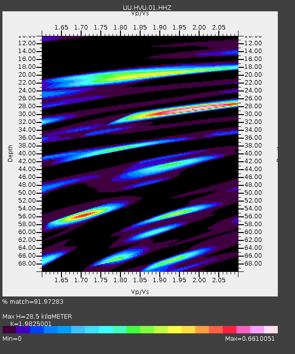
| Estimated Moho Depth: |
28.5 km |
| Estimated Crust Vp/Vs: |
1.98 |
| Assumed Crust Vp: |
6.276 km/s |
| Estimated Crust Vs: |
3.166 km/s |
| Estimated Crust Poisson's Ratio: |
0.33 |
|
| Radial Match: |
91.97283 % |
| Radial Bump: |
333 |
| Transverse Match: |
83.5818 % |
| Transverse Bump: |
333 |
| SOD ConfigId: |
512894 |
| Insert Time: |
2013-09-14 04:33:37.422 +0000 |
| GWidth: |
2.5 |
| Max Bumps: |
400 |
| Tol: |
0.001 |
|
Signal To Noise
| Channel | StoN | STA | LTA |
| UU:HVU:01:HHZ:20130514T00:43:33.618027Z | 106.85025 | 1.5034001E-7 | 1.4070161E-9 |
| UU:HVU:01:HHN:20130514T00:43:33.618027Z | 13.419597 | 2.0074083E-8 | 1.4958783E-9 |
| UU:HVU:01:HHE:20130514T00:43:33.618027Z | 29.92066 | 4.4246704E-8 | 1.4788011E-9 |
| Arrivals |
| Ps | 4.5 SECOND |
| PpPs | 13 SECOND |
| PsPs/PpSs | 18 SECOND |


