You are here: Home > Network List > UU - University of Utah Regional Network Stations List
> Station LCMT Little Creek Mountain, UT, USA > Earthquake Result Viewer
LCMT Little Creek Mountain, UT, USA - Earthquake Result Viewer
| Earthquake location: |
Mariana Islands |
| Earthquake latitude/longitude: |
18.7/145.3 |
| Earthquake time(UTC): |
2013/05/14 (134) 00:32:25 GMT |
| Earthquake Depth: |
602 km |
| Earthquake Magnitude: |
6.8 MW, 6.2 MB, 6.8 MW |
| Earthquake Catalog/Contributor: |
NEIC PDE/NEIC PDE-W |
|
| Network: |
UU University of Utah Regional Network |
| Station: |
LCMT Little Creek Mountain, UT, USA |
| Lat/Lon: |
37.01 N/113.24 W |
| Elevation: |
1411 m |
|
| Distance: |
87.7 deg |
| Az: |
51.731 deg |
| Baz: |
291.636 deg |
| Ray Param: |
0.041702755 |
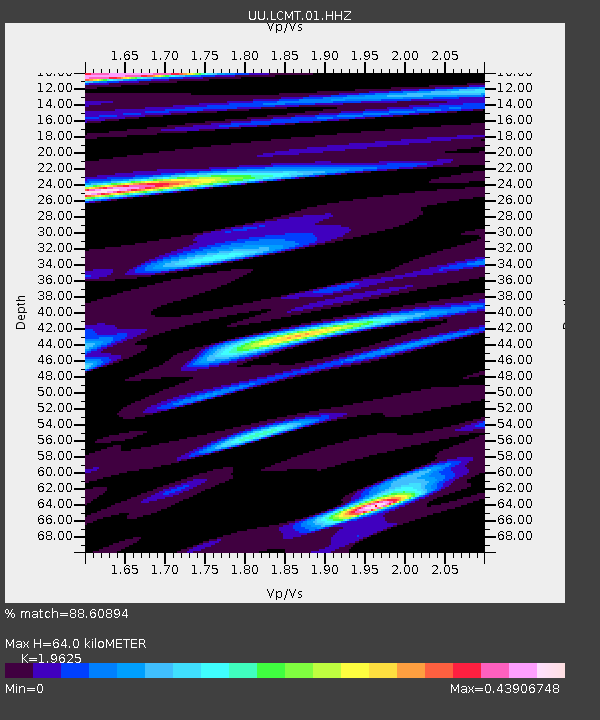
| Estimated Moho Depth: |
64.0 km |
| Estimated Crust Vp/Vs: |
1.96 |
| Assumed Crust Vp: |
6.194 km/s |
| Estimated Crust Vs: |
3.156 km/s |
| Estimated Crust Poisson's Ratio: |
0.32 |
|
| Radial Match: |
88.60894 % |
| Radial Bump: |
339 |
| Transverse Match: |
78.38942 % |
| Transverse Bump: |
338 |
| SOD ConfigId: |
512894 |
| Insert Time: |
2013-09-14 04:33:45.782 +0000 |
| GWidth: |
2.5 |
| Max Bumps: |
400 |
| Tol: |
0.001 |
|
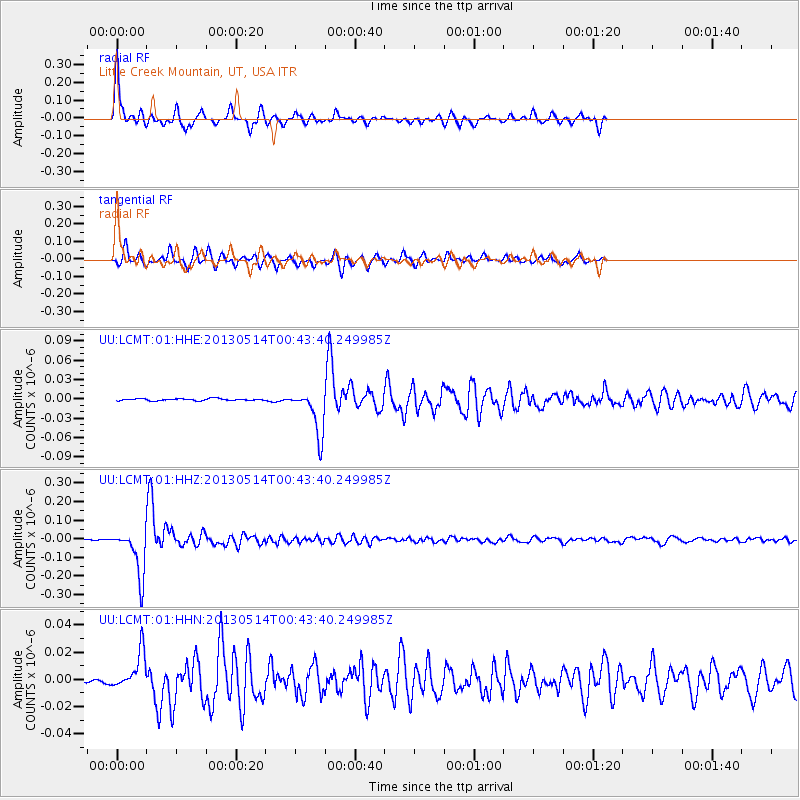
Signal To Noise
| Channel | StoN | STA | LTA |
| UU:LCMT:01:HHZ:20130514T00:43:40.249985Z | 118.47715 | 1.2580125E-7 | 1.0618186E-9 |
| UU:LCMT:01:HHN:20130514T00:43:40.249985Z | 13.238175 | 1.36664555E-8 | 1.0323519E-9 |
| UU:LCMT:01:HHE:20130514T00:43:40.249985Z | 22.72351 | 3.537433E-8 | 1.5567283E-9 |
| Arrivals |
| Ps | 10 SECOND |
| PpPs | 30 SECOND |
| PsPs/PpSs | 40 SECOND |


