You are here: Home > Network List > UW - Pacific Northwest Regional Seismic Network Stations List
> Station BABR Baber Butte, OR, USA > Earthquake Result Viewer
BABR Baber Butte, OR, USA - Earthquake Result Viewer
| Earthquake location: |
Mariana Islands |
| Earthquake latitude/longitude: |
18.7/145.3 |
| Earthquake time(UTC): |
2013/05/14 (134) 00:32:25 GMT |
| Earthquake Depth: |
602 km |
| Earthquake Magnitude: |
6.8 MW, 6.2 MB, 6.8 MW |
| Earthquake Catalog/Contributor: |
NEIC PDE/NEIC PDE-W |
|
| Network: |
UW Pacific Northwest Regional Seismic Network |
| Station: |
BABR Baber Butte, OR, USA |
| Lat/Lon: |
44.62 N/123.79 W |
| Elevation: |
418 m |
|
| Distance: |
77.7 deg |
| Az: |
46.947 deg |
| Baz: |
284.133 deg |
| Ray Param: |
0.048212398 |
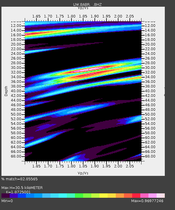
| Estimated Moho Depth: |
30.5 km |
| Estimated Crust Vp/Vs: |
1.87 |
| Assumed Crust Vp: |
6.566 km/s |
| Estimated Crust Vs: |
3.507 km/s |
| Estimated Crust Poisson's Ratio: |
0.30 |
|
| Radial Match: |
82.85565 % |
| Radial Bump: |
400 |
| Transverse Match: |
74.38741 % |
| Transverse Bump: |
400 |
| SOD ConfigId: |
512894 |
| Insert Time: |
2013-09-14 04:34:34.973 +0000 |
| GWidth: |
2.5 |
| Max Bumps: |
400 |
| Tol: |
0.001 |
|

Signal To Noise
| Channel | StoN | STA | LTA |
| UW:BABR: :BHZ:20130514T00:42:50.705002Z | 10.915559 | 6.9367984E-6 | 6.354964E-7 |
| UW:BABR: :BHN:20130514T00:42:50.705002Z | 1.3779591 | 1.0527851E-6 | 7.6401767E-7 |
| UW:BABR: :BHE:20130514T00:42:50.705002Z | 2.6257465 | 2.7430954E-6 | 1.0446917E-6 |
| Arrivals |
| Ps | 4.2 SECOND |
| PpPs | 13 SECOND |
| PsPs/PpSs | 17 SECOND |


