You are here: Home > Network List > GO - National Seismic Network of Georgia Stations List
> Station TBLG Delisi, Georgia > Earthquake Result Viewer
TBLG Delisi, Georgia - Earthquake Result Viewer
| Earthquake location: |
Off W Coast Of Northern Sumatra |
| Earthquake latitude/longitude: |
0.8/92.4 |
| Earthquake time(UTC): |
2013/05/14 (134) 19:18:16 GMT |
| Earthquake Depth: |
17 km |
| Earthquake Magnitude: |
5.6 MW, 5.6 MB, 5.7 MW |
| Earthquake Catalog/Contributor: |
NEIC PDE/NEIC PDE-W |
|
| Network: |
GO National Seismic Network of Georgia |
| Station: |
TBLG Delisi, Georgia |
| Lat/Lon: |
41.73 N/44.74 E |
| Elevation: |
510 m |
|
| Distance: |
59.1 deg |
| Az: |
319.873 deg |
| Baz: |
120.575 deg |
| Ray Param: |
0.06236644 |
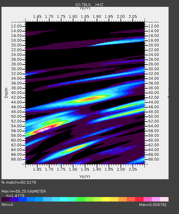
| Estimated Moho Depth: |
55.25 km |
| Estimated Crust Vp/Vs: |
1.68 |
| Assumed Crust Vp: |
6.291 km/s |
| Estimated Crust Vs: |
3.75 km/s |
| Estimated Crust Poisson's Ratio: |
0.22 |
|
| Radial Match: |
80.5279 % |
| Radial Bump: |
400 |
| Transverse Match: |
80.646225 % |
| Transverse Bump: |
400 |
| SOD ConfigId: |
512894 |
| Insert Time: |
2013-09-14 04:41:52.754 +0000 |
| GWidth: |
2.5 |
| Max Bumps: |
400 |
| Tol: |
0.001 |
|

Signal To Noise
| Channel | StoN | STA | LTA |
| GO:TBLG: :HHZ:20130514T19:27:45.220027Z | 9.904493 | 6.8571234E-7 | 6.923245E-8 |
| GO:TBLG: :HHN:20130514T19:27:45.220027Z | 2.2216585 | 2.11146E-7 | 9.503981E-8 |
| GO:TBLG: :HHE:20130514T19:27:45.220027Z | 4.1747365 | 2.2221553E-7 | 5.3228636E-8 |
| Arrivals |
| Ps | 6.2 SECOND |
| PpPs | 22 SECOND |
| PsPs/PpSs | 29 SECOND |


