You are here: Home > Network List > PS - Pacific21 Stations List
> Station SYO Syowa Station, Antarctica > Earthquake Result Viewer
SYO Syowa Station, Antarctica - Earthquake Result Viewer

| Earthquake location: |
Lake Tanganyika Region |
| Earthquake latitude/longitude: |
-8.0/30.7 |
| Earthquake time(UTC): |
2000/10/02 (276) 02:25:31 GMT |
| Earthquake Depth: |
34 km |
| Earthquake Magnitude: |
6.1 MB, 6.7 MS, 6.5 MW, 6.2 ME |
| Earthquake Catalog/Contributor: |
WHDF/NEIC |
|
| Network: |
PS Pacific21 |
| Station: |
SYO Syowa Station, Antarctica |
| Lat/Lon: |
69.01 S/39.58 E |
| Elevation: |
20 m |
|
| Distance: |
61.2 deg |
| Az: |
176.363 deg |
| Baz: |
349.96 deg |
| Ray Param: |
0.060947854 |
| Estimated Moho Depth: |
40.75 km |
| Estimated Crust Vp/Vs: |
1.65 |
| Assumed Crust Vp: |
6.508 km/s |
| Estimated Crust Vs: |
3.938 km/s |
| Estimated Crust Poisson's Ratio: |
0.21 |
|
| Radial Match: |
95.98019 % |
| Radial Bump: |
303 |
| Transverse Match: |
85.74623 % |
| Transverse Bump: |
400 |
| SOD ConfigId: |
3744 |
| Insert Time: |
2010-02-27 03:34:23.704 +0000 |
| GWidth: |
2.5 |
| Max Bumps: |
400 |
| Tol: |
0.001 |
|
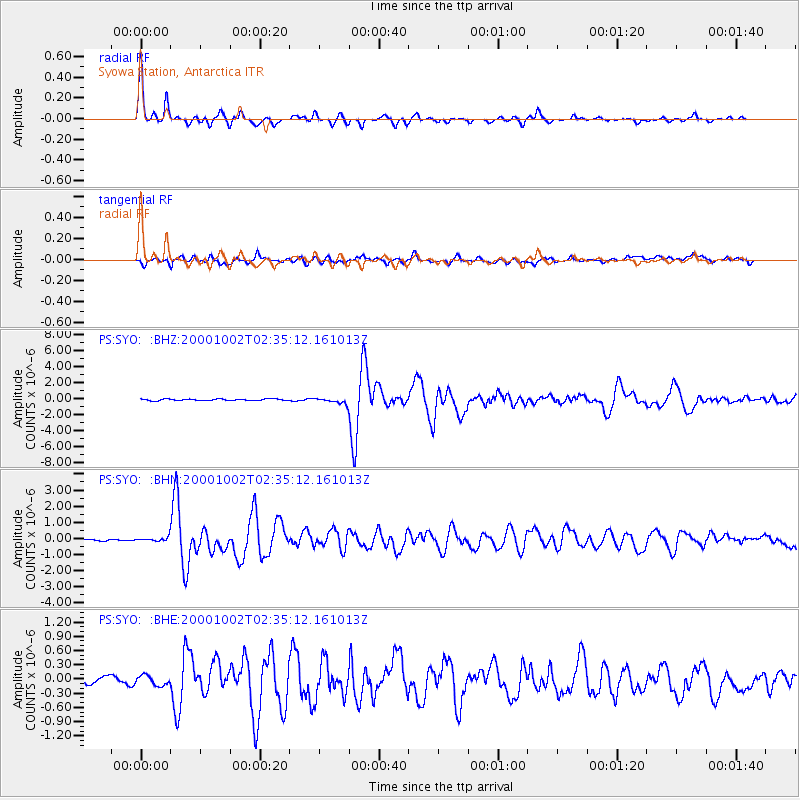
Signal To Noise
| Channel | StoN | STA | LTA |
| PS:SYO: :BHN:20001002T02:35:12.161013Z | 2.4357162 | 1.2555384E-7 | 5.154699E-8 |
| PS:SYO: :BHE:20001002T02:35:12.161013Z | 1.3447858 | 1.0470445E-7 | 7.785957E-8 |
| PS:SYO: :BHZ:20001002T02:35:12.161013Z | 3.2457285 | 3.391429E-7 | 1.0448899E-7 |
| Arrivals |
| Ps | 4.3 SECOND |
| PpPs | 16 SECOND |
| PsPs/PpSs | 20 SECOND |


