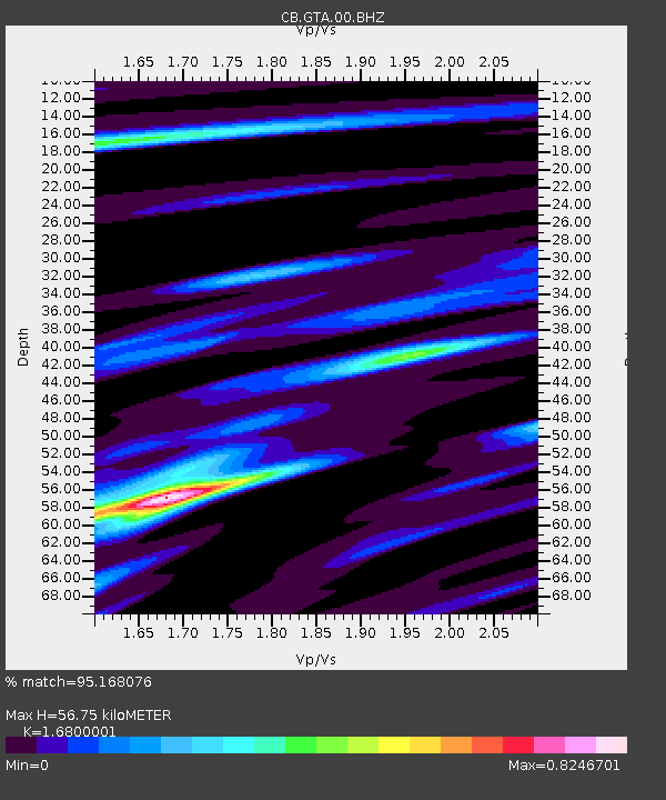
GTA Gaotai,Gansu Province - Earthquake Result Viewer

Earthquake location: E. Caroline Islands, Micronesia
Earthquake latitude/longitude: 0.8/146.1
Earthquake time(UTC): 2014/08/03 (215) 00:22:03 GMT
Earthquake Depth: 11 km
Earthquake Magnitude: 6.9 MWW, 6.8 MWB, 6.9 MWC, 7.2 MI
Earthquake Catalog/Contributor: NEIC PDE/NEIC COMCAT
Network: CB China National Seismic Network
Station: GTA Gaotai,Gansu Province
Lat/Lon: 39.40 N/99.82 E
Elevation: 1345 m
Distance: 57.0 deg
Az: 318.085 deg
Baz: 120.45 deg
Ray Param: 0.063753486
Estimated Moho Depth: 56.75 km
Estimated Crust Vp/Vs: 1.68
Assumed Crust Vp: 6.491 km/s
Estimated Crust Vs: 3.864 km/s
Estimated Crust Poisson's Ratio: 0.23
Radial Match: 95.168076 %
Radial Bump: 261
Transverse Match: 74.080986 %
Transverse Bump: 400
SOD ConfigId: 3390531
Insert Time: 2019-04-13 04:02:36.650 +0000
GWidth: 2.5
Max Bumps: 400
Tol: 0.001

Signal To Noise

ChannelStoNSTALTA
CB:GTA:00:BHZ:20140803T00:31:18.100015Z30.9613868.8523217E-72.859149E-8
CB:GTA:00:BHN:20140803T00:31:18.100015Z8.2267371.8465329E-72.2445507E-8
CB:GTA:00:BHE:20140803T00:31:18.100015Z15.1350043.9535004E-72.6121569E-8
Arrivals
Ps6.3 SECOND
PpPs22 SECOND
PsPs/PpSs28 SECOND