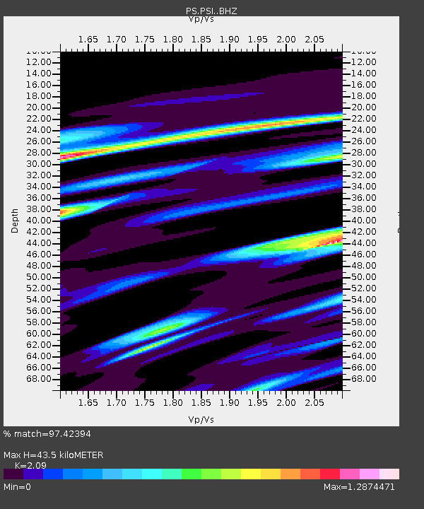
PSI Parapat, Indonesia - Earthquake Result Viewer
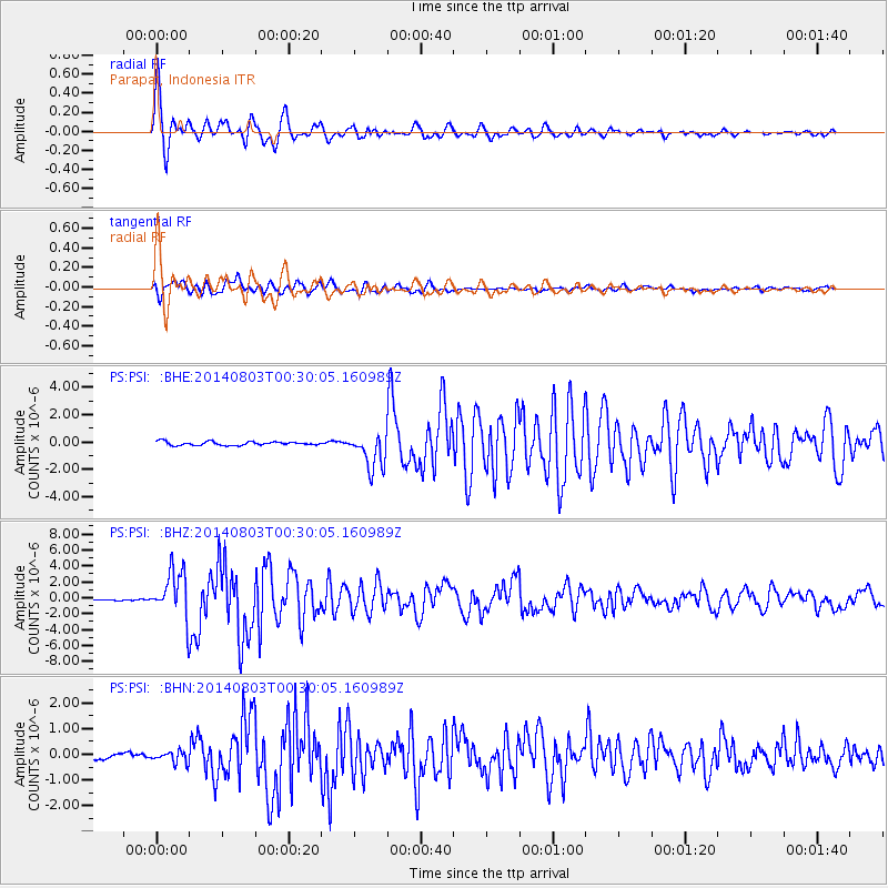
Earthquake location: E. Caroline Islands, Micronesia
Earthquake latitude/longitude: 0.8/146.1
Earthquake time(UTC): 2014/08/03 (215) 00:22:03 GMT
Earthquake Depth: 11 km
Earthquake Magnitude: 6.9 MWW, 6.8 MWB, 6.9 MWC, 7.2 MI
Earthquake Catalog/Contributor: NEIC PDE/NEIC COMCAT
Network: PS Pacific21
Station: PSI Parapat, Indonesia
Lat/Lon: 2.69 N/98.92 E
Elevation: 987 m
Distance: 47.2 deg
Az: 272.87 deg
Baz: 91.334 deg
Ray Param: 0.07012612
Estimated Moho Depth: 43.5 km
Estimated Crust Vp/Vs: 2.09
Assumed Crust Vp: 6.468 km/s
Estimated Crust Vs: 3.095 km/s
Estimated Crust Poisson's Ratio: 0.35
Radial Match: 97.42394 %
Radial Bump: 400
Transverse Match: 95.13956 %
Transverse Bump: 400
SOD ConfigId: 3390531
Insert Time: 2019-04-13 04:04:28.981 +0000
GWidth: 2.5
Max Bumps: 400
Tol: 0.001

Signal To Noise

ChannelStoNSTALTA
PS:PSI: :BHZ:20140803T00:30:05.160989Z40.7944223.0293586E-67.4259134E-8
PS:PSI: :BHN:20140803T00:30:05.160989Z1.95636682.265589E-71.15805946E-7
PS:PSI: :BHE:20140803T00:30:05.160989Z9.8407611.3006513E-61.3216979E-7
Arrivals
Ps7.7 SECOND
PpPs20 SECOND
PsPs/PpSs27 SECOND