You are here: Home > Network List > TA - USArray Transportable Network (new EarthScope stations) Stations List
> Station V56A Mocksville, NC, USA > Earthquake Result Viewer
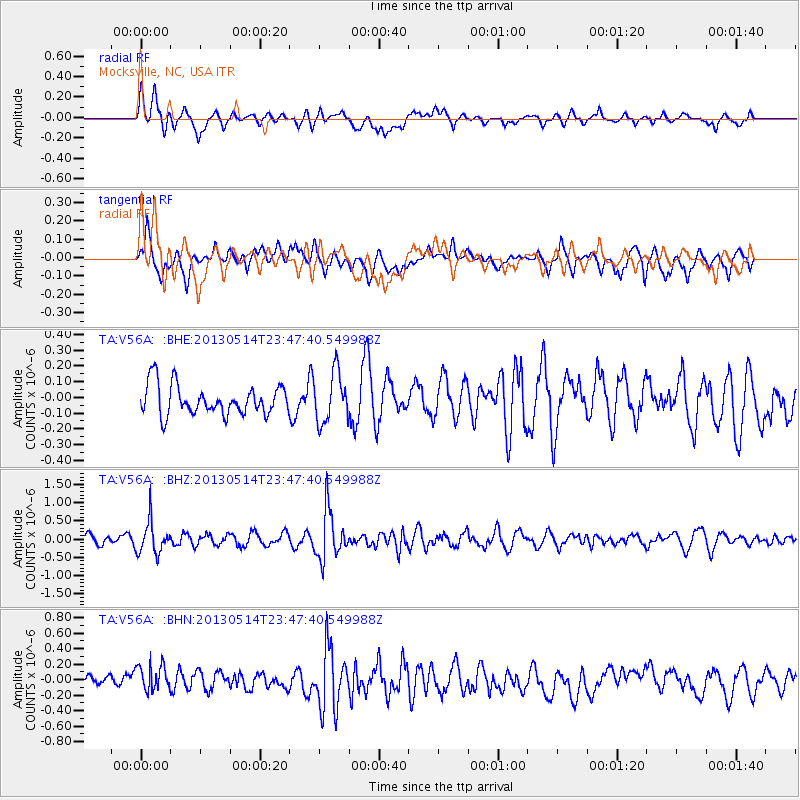
V56A Mocksville, NC, USA - Earthquake Result Viewer
*The percent match for this event was below the threshold and hence no stack was calculated.
| Earthquake location: |
Southern Peru |
| Earthquake latitude/longitude: |
-15.7/-73.3 |
| Earthquake time(UTC): |
2013/05/14 (134) 23:39:15 GMT |
| Earthquake Depth: |
105 km |
| Earthquake Magnitude: |
5.5 MW, 5.5 MW, 5.7 MB |
| Earthquake Catalog/Contributor: |
NEIC PDE/NEIC PDE-W |
|
| Network: |
TA USArray Transportable Network (new EarthScope stations) |
| Station: |
V56A Mocksville, NC, USA |
| Lat/Lon: |
35.81 N/80.50 W |
| Elevation: |
237 m |
|
| Distance: |
51.7 deg |
| Az: |
352.573 deg |
| Baz: |
171.188 deg |
| Ray Param: |
$rayparam |
*The percent match for this event was below the threshold and hence was not used in the summary stack. |
|
| Radial Match: |
61.1398 % |
| Radial Bump: |
400 |
| Transverse Match: |
61.058464 % |
| Transverse Bump: |
400 |
| SOD ConfigId: |
512894 |
| Insert Time: |
2013-09-14 05:31:50.971 +0000 |
| GWidth: |
2.5 |
| Max Bumps: |
400 |
| Tol: |
0.001 |
|
Signal To Noise
| Channel | StoN | STA | LTA |
| TA:V56A: :BHZ:20130514T23:47:40.549988Z | 2.8489988 | 4.405528E-7 | 1.5463425E-7 |
| TA:V56A: :BHN:20130514T23:47:40.549988Z | 1.2014769 | 1.7818641E-7 | 1.4830616E-7 |
| TA:V56A: :BHE:20130514T23:47:40.549988Z | 1.6859456 | 1.5975009E-7 | 9.475399E-8 |
| Arrivals |
| Ps | |
| PpPs | |
| PsPs/PpSs | |


