You are here: Home > Network List > TA - USArray Transportable Network (new EarthScope stations) Stations List
> Station V60A Jim Taylor Road, Stokes, NC, USA > Earthquake Result Viewer
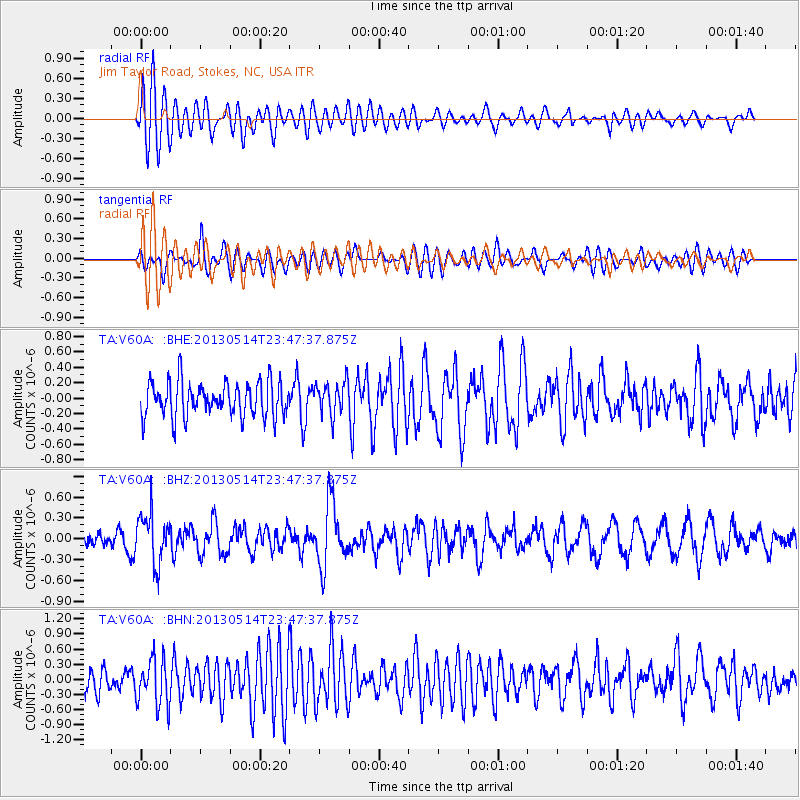
V60A Jim Taylor Road, Stokes, NC, USA - Earthquake Result Viewer
*The percent match for this event was below the threshold and hence no stack was calculated.
| Earthquake location: |
Southern Peru |
| Earthquake latitude/longitude: |
-15.7/-73.3 |
| Earthquake time(UTC): |
2013/05/14 (134) 23:39:15 GMT |
| Earthquake Depth: |
105 km |
| Earthquake Magnitude: |
5.5 MW, 5.5 MW, 5.7 MB |
| Earthquake Catalog/Contributor: |
NEIC PDE/NEIC PDE-W |
|
| Network: |
TA USArray Transportable Network (new EarthScope stations) |
| Station: |
V60A Jim Taylor Road, Stokes, NC, USA |
| Lat/Lon: |
35.76 N/77.26 W |
| Elevation: |
8.0 m |
|
| Distance: |
51.3 deg |
| Az: |
355.902 deg |
| Baz: |
175.145 deg |
| Ray Param: |
$rayparam |
*The percent match for this event was below the threshold and hence was not used in the summary stack. |
|
| Radial Match: |
63.942863 % |
| Radial Bump: |
400 |
| Transverse Match: |
51.824234 % |
| Transverse Bump: |
400 |
| SOD ConfigId: |
512894 |
| Insert Time: |
2013-09-14 05:32:01.312 +0000 |
| GWidth: |
2.5 |
| Max Bumps: |
400 |
| Tol: |
0.001 |
|
Signal To Noise
| Channel | StoN | STA | LTA |
| TA:V60A: :BHZ:20130514T23:47:37.875Z | 3.1528537 | 3.5941335E-7 | 1.13996194E-7 |
| TA:V60A: :BHN:20130514T23:47:37.875Z | 1.4357764 | 4.6557048E-7 | 3.2426394E-7 |
| TA:V60A: :BHE:20130514T23:47:37.875Z | 0.95117384 | 2.1454906E-7 | 2.255624E-7 |
| Arrivals |
| Ps | |
| PpPs | |
| PsPs/PpSs | |


