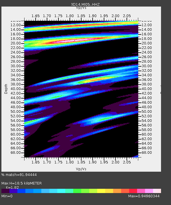
MI05 "Mount St Helens, WA" - Earthquake Result Viewer

Earthquake location: E. Caroline Islands, Micronesia
Earthquake latitude/longitude: 0.8/146.1
Earthquake time(UTC): 2014/08/03 (215) 00:22:03 GMT
Earthquake Depth: 11 km
Earthquake Magnitude: 6.9 MWW, 6.8 MWB, 6.9 MWC, 7.2 MI
Earthquake Catalog/Contributor: NEIC PDE/NEIC COMCAT
Network: XD Illuminating the architecture of the greater Mount St. Helens magmatic systems f
Station: MI05 "Mount St Helens, WA"
Lat/Lon: 46.23 N/122.29 W
Elevation: 1255 m
Distance: 90.5 deg
Az: 43.943 deg
Baz: 271.707 deg
Ray Param: 0.04167016
Estimated Moho Depth: 18.5 km
Estimated Crust Vp/Vs: 1.82
Assumed Crust Vp: 6.566 km/s
Estimated Crust Vs: 3.608 km/s
Estimated Crust Poisson's Ratio: 0.28
Radial Match: 91.94444 %
Radial Bump: 258
Transverse Match: 82.247154 %
Transverse Bump: 400
SOD ConfigId: 3390531
Insert Time: 2019-04-13 04:06:00.813 +0000
GWidth: 2.5
Max Bumps: 400
Tol: 0.001

Signal To Noise

ChannelStoNSTALTA
XD:MI05: :HHZ:20140803T00:34:33.795022Z5.9098525.0184474E-78.4916636E-8
XD:MI05: :HHN:20140803T00:34:33.795022Z0.85559628.113535E-89.482902E-8
XD:MI05: :HHE:20140803T00:34:33.795022Z3.159891.8830758E-75.9593084E-8
Arrivals
Ps2.4 SECOND
PpPs7.8 SECOND
PsPs/PpSs10 SECOND