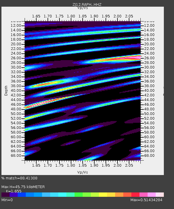
RAPH Exposure Hill, Antarctica - Earthquake Result Viewer

Earthquake location: E. Caroline Islands, Micronesia
Earthquake latitude/longitude: 0.8/146.1
Earthquake time(UTC): 2014/08/03 (215) 00:22:03 GMT
Earthquake Depth: 11 km
Earthquake Magnitude: 6.9 MWW, 6.8 MWB, 6.9 MWC, 7.2 MI
Earthquake Catalog/Contributor: NEIC PDE/NEIC COMCAT
Network: ZJ Transantarctic Mountains Northern Network
Station: RAPH Exposure Hill, Antarctica
Lat/Lon: 73.60 S/162.29 E
Elevation: 3052 m
Distance: 75.0 deg
Az: 175.308 deg
Baz: 343.272 deg
Ray Param: 0.051958032
Estimated Moho Depth: 45.75 km
Estimated Crust Vp/Vs: 1.65
Assumed Crust Vp: 6.264 km/s
Estimated Crust Vs: 3.785 km/s
Estimated Crust Poisson's Ratio: 0.21
Radial Match: 88.41308 %
Radial Bump: 400
Transverse Match: 76.41902 %
Transverse Bump: 400
SOD ConfigId: 3390531
Insert Time: 2019-04-13 04:07:12.090 +0000
GWidth: 2.5
Max Bumps: 400
Tol: 0.001

Signal To Noise

ChannelStoNSTALTA
ZJ:RAPH: :HHZ:20140803T00:33:13.449014Z5.7293238.071799E-71.4088575E-7
ZJ:RAPH: :HHN:20140803T00:33:13.449014Z2.016113.0231809E-71.4995119E-7
ZJ:RAPH: :HHE:20140803T00:33:13.449014Z2.32876542.8247914E-71.2129995E-7
Arrivals
Ps4.9 SECOND
PpPs19 SECOND
PsPs/PpSs24 SECOND