You are here: Home > Network List > PS - Pacific21 Stations List
> Station SYO Syowa Station, Antarctica > Earthquake Result Viewer
SYO Syowa Station, Antarctica - Earthquake Result Viewer
| Earthquake location: |
Sunda Strait, Indonesia |
| Earthquake latitude/longitude: |
-7.0/104.2 |
| Earthquake time(UTC): |
2002/06/27 (178) 05:50:35 GMT |
| Earthquake Depth: |
11 km |
| Earthquake Magnitude: |
6.0 MB, 6.9 MS, 6.6 MW, 6.5 MW |
| Earthquake Catalog/Contributor: |
WHDF/NEIC |
|
| Network: |
PS Pacific21 |
| Station: |
SYO Syowa Station, Antarctica |
| Lat/Lon: |
69.01 S/39.58 E |
| Elevation: |
20 m |
|
| Distance: |
74.6 deg |
| Az: |
199.735 deg |
| Baz: |
68.465 deg |
| Ray Param: |
0.052232657 |
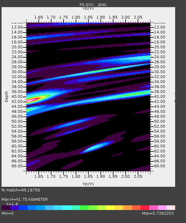
| Estimated Moho Depth: |
41.75 km |
| Estimated Crust Vp/Vs: |
1.60 |
| Assumed Crust Vp: |
6.508 km/s |
| Estimated Crust Vs: |
4.067 km/s |
| Estimated Crust Poisson's Ratio: |
0.18 |
|
| Radial Match: |
95.16755 % |
| Radial Bump: |
376 |
| Transverse Match: |
87.113884 % |
| Transverse Bump: |
400 |
| SOD ConfigId: |
20082 |
| Insert Time: |
2010-02-27 03:35:18.720 +0000 |
| GWidth: |
2.5 |
| Max Bumps: |
400 |
| Tol: |
0.001 |
|
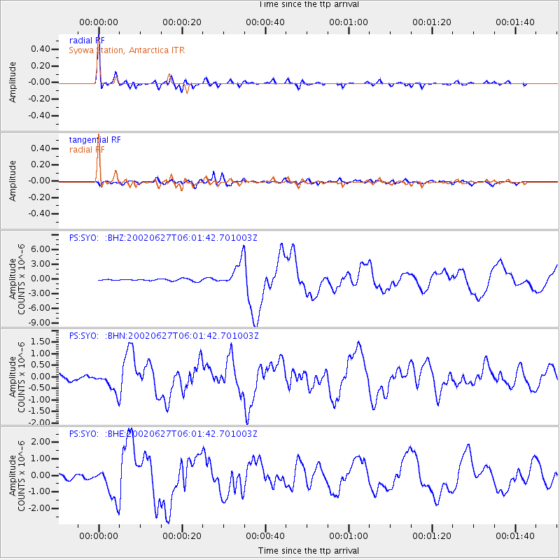
Signal To Noise
| Channel | StoN | STA | LTA |
| PS:SYO: :BHN:20020627T06:01:42.701003Z | 2.6768403 | 4.461413E-7 | 1.6666714E-7 |
| PS:SYO: :BHE:20020627T06:01:42.701003Z | 6.2941093 | 1.0493739E-6 | 1.6672317E-7 |
| PS:SYO: :BHZ:20020627T06:01:42.701003Z | 13.727604 | 2.6767418E-6 | 1.9498974E-7 |
| Arrivals |
| Ps | 4.0 SECOND |
| PpPs | 16 SECOND |
| PsPs/PpSs | 20 SECOND |


