You are here: Home > Network List > PS - Pacific21 Stations List
> Station SYO Syowa Station, Antarctica > Earthquake Result Viewer
SYO Syowa Station, Antarctica - Earthquake Result Viewer
| Earthquake location: |
Sunda Strait, Indonesia |
| Earthquake latitude/longitude: |
-6.3/105.2 |
| Earthquake time(UTC): |
2002/01/15 (015) 07:12:58 GMT |
| Earthquake Depth: |
10 km |
| Earthquake Magnitude: |
5.8 MB, 6.3 MS, 6.2 MW, 6.1 MW |
| Earthquake Catalog/Contributor: |
WHDF/NEIC |
|
| Network: |
PS Pacific21 |
| Station: |
SYO Syowa Station, Antarctica |
| Lat/Lon: |
69.01 S/39.58 E |
| Elevation: |
20 m |
|
| Distance: |
75.5 deg |
| Az: |
199.814 deg |
| Baz: |
69.23 deg |
| Ray Param: |
0.051602904 |
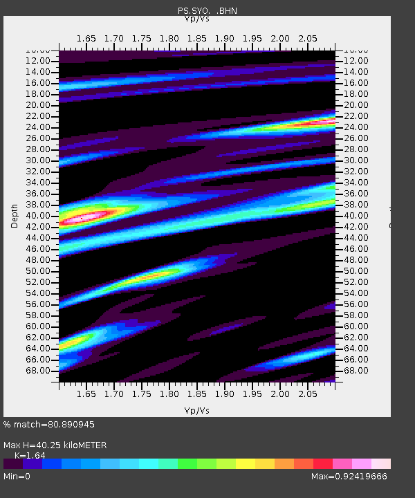
| Estimated Moho Depth: |
40.25 km |
| Estimated Crust Vp/Vs: |
1.64 |
| Assumed Crust Vp: |
6.508 km/s |
| Estimated Crust Vs: |
3.968 km/s |
| Estimated Crust Poisson's Ratio: |
0.20 |
|
| Radial Match: |
80.890945 % |
| Radial Bump: |
369 |
| Transverse Match: |
67.67115 % |
| Transverse Bump: |
400 |
| SOD ConfigId: |
20082 |
| Insert Time: |
2010-02-27 03:35:26.782 +0000 |
| GWidth: |
2.5 |
| Max Bumps: |
400 |
| Tol: |
0.001 |
|

Signal To Noise
| Channel | StoN | STA | LTA |
| PS:SYO: :BHN:20020115T07:24:11.29001Z | 0.9226106 | 6.514193E-8 | 7.06061E-8 |
| PS:SYO: :BHE:20020115T07:24:11.29001Z | 1.7576017 | 1.5567157E-7 | 8.8570445E-8 |
| PS:SYO: :BHZ:20020115T07:24:11.29001Z | 3.036446 | 2.790074E-7 | 9.1886164E-8 |
| Arrivals |
| Ps | 4.1 SECOND |
| PpPs | 16 SECOND |
| PsPs/PpSs | 20 SECOND |


