You are here: Home > Network List > PS - Pacific21 Stations List
> Station SYO Syowa Station, Antarctica > Earthquake Result Viewer
SYO Syowa Station, Antarctica - Earthquake Result Viewer
| Earthquake location: |
Lake Tanganyika Region |
| Earthquake latitude/longitude: |
-1.9/29.0 |
| Earthquake time(UTC): |
2002/10/24 (297) 06:08:37 GMT |
| Earthquake Depth: |
11 km |
| Earthquake Magnitude: |
5.9 MB, 6.3 MS, 6.2 MW, 6.1 MW |
| Earthquake Catalog/Contributor: |
WHDF/NEIC |
|
| Network: |
PS Pacific21 |
| Station: |
SYO Syowa Station, Antarctica |
| Lat/Lon: |
69.01 S/39.58 E |
| Elevation: |
20 m |
|
| Distance: |
67.4 deg |
| Az: |
175.889 deg |
| Baz: |
348.533 deg |
| Ray Param: |
0.056987677 |
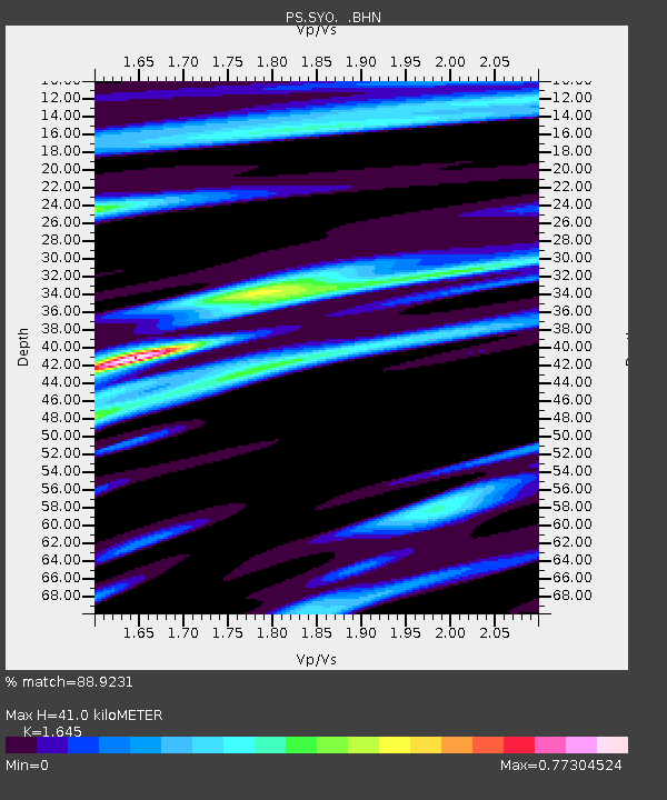
| Estimated Moho Depth: |
41.0 km |
| Estimated Crust Vp/Vs: |
1.64 |
| Assumed Crust Vp: |
6.508 km/s |
| Estimated Crust Vs: |
3.956 km/s |
| Estimated Crust Poisson's Ratio: |
0.21 |
|
| Radial Match: |
88.9231 % |
| Radial Bump: |
334 |
| Transverse Match: |
73.181694 % |
| Transverse Bump: |
400 |
| SOD ConfigId: |
4714 |
| Insert Time: |
2010-02-27 03:35:43.522 +0000 |
| GWidth: |
2.5 |
| Max Bumps: |
400 |
| Tol: |
0.001 |
|
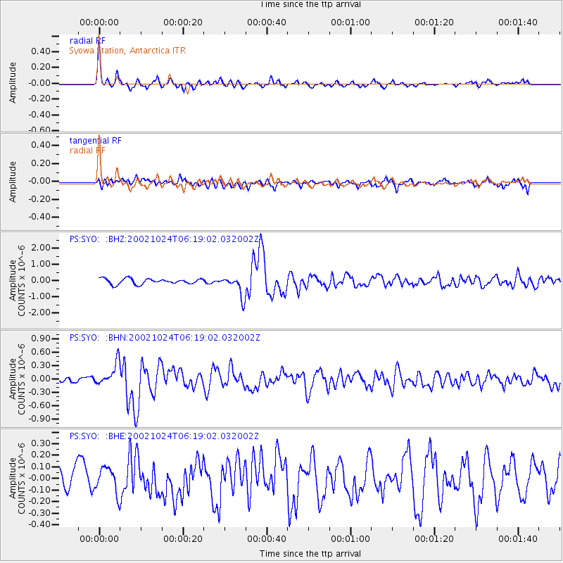
Signal To Noise
| Channel | StoN | STA | LTA |
| PS:SYO: :BHN:20021024T06:19:02.032002Z | 4.811362 | 2.7423837E-7 | 5.699808E-8 |
| PS:SYO: :BHE:20021024T06:19:02.032002Z | 1.0993984 | 1.16698324E-7 | 1.0614744E-7 |
| PS:SYO: :BHZ:20021024T06:19:02.032002Z | 3.9858308 | 6.6531857E-7 | 1.6692093E-7 |
| Arrivals |
| Ps | 4.2 SECOND |
| PpPs | 16 SECOND |
| PsPs/PpSs | 20 SECOND |


