You are here: Home > Network List > TA - USArray Transportable Network (new EarthScope stations) Stations List
> Station O03E Paynes Creek, CA, USA > Earthquake Result Viewer
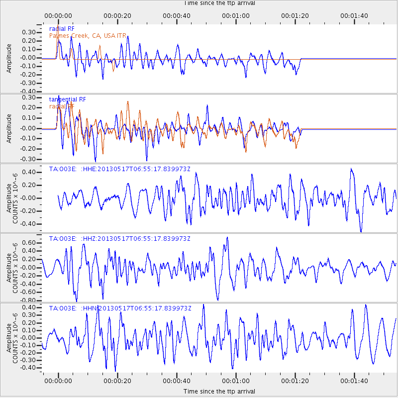
O03E Paynes Creek, CA, USA - Earthquake Result Viewer
*The percent match for this event was below the threshold and hence no stack was calculated.
| Earthquake location: |
Santa Cruz Islands |
| Earthquake latitude/longitude: |
-11.1/165.1 |
| Earthquake time(UTC): |
2013/05/17 (137) 06:43:15 GMT |
| Earthquake Depth: |
7.0 km |
| Earthquake Magnitude: |
5.7 MW, 5.5 MS, 5.7 MW, 5.8 MB |
| Earthquake Catalog/Contributor: |
NEIC PDE/NEIC PDE-W |
|
| Network: |
TA USArray Transportable Network (new EarthScope stations) |
| Station: |
O03E Paynes Creek, CA, USA |
| Lat/Lon: |
40.29 N/121.80 W |
| Elevation: |
967 m |
|
| Distance: |
84.5 deg |
| Az: |
47.328 deg |
| Baz: |
250.67 deg |
| Ray Param: |
$rayparam |
*The percent match for this event was below the threshold and hence was not used in the summary stack. |
|
| Radial Match: |
60.45765 % |
| Radial Bump: |
400 |
| Transverse Match: |
70.501564 % |
| Transverse Bump: |
400 |
| SOD ConfigId: |
512894 |
| Insert Time: |
2013-09-14 06:22:26.970 +0000 |
| GWidth: |
2.5 |
| Max Bumps: |
400 |
| Tol: |
0.001 |
|
Signal To Noise
| Channel | StoN | STA | LTA |
| TA:O03E: :HHZ:20130517T06:55:17.839973Z | 2.0193353 | 2.511768E-7 | 1.2438588E-7 |
| TA:O03E: :HHN:20130517T06:55:17.839973Z | 1.1761756 | 9.8514505E-8 | 8.375833E-8 |
| TA:O03E: :HHE:20130517T06:55:17.839973Z | 1.4229023 | 1.332725E-7 | 9.366243E-8 |
| Arrivals |
| Ps | |
| PpPs | |
| PsPs/PpSs | |


