You are here: Home > Network List > US - United States National Seismic Network Stations List
> Station ELK Elko, Nevada, USA > Earthquake Result Viewer
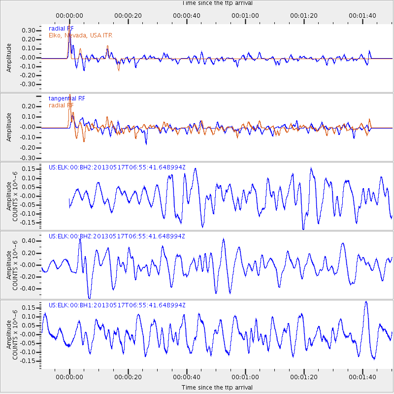
ELK Elko, Nevada, USA - Earthquake Result Viewer
*The percent match for this event was below the threshold and hence no stack was calculated.
| Earthquake location: |
Santa Cruz Islands |
| Earthquake latitude/longitude: |
-11.1/165.1 |
| Earthquake time(UTC): |
2013/05/17 (137) 06:43:15 GMT |
| Earthquake Depth: |
7.0 km |
| Earthquake Magnitude: |
5.7 MW, 5.5 MS, 5.7 MW, 5.8 MB |
| Earthquake Catalog/Contributor: |
NEIC PDE/NEIC PDE-W |
|
| Network: |
US United States National Seismic Network |
| Station: |
ELK Elko, Nevada, USA |
| Lat/Lon: |
40.74 N/115.24 W |
| Elevation: |
2210 m |
|
| Distance: |
89.4 deg |
| Az: |
48.377 deg |
| Baz: |
254.976 deg |
| Ray Param: |
$rayparam |
*The percent match for this event was below the threshold and hence was not used in the summary stack. |
|
| Radial Match: |
69.701744 % |
| Radial Bump: |
400 |
| Transverse Match: |
53.71961 % |
| Transverse Bump: |
400 |
| SOD ConfigId: |
512894 |
| Insert Time: |
2013-09-14 06:23:22.414 +0000 |
| GWidth: |
2.5 |
| Max Bumps: |
400 |
| Tol: |
0.001 |
|
Signal To Noise
| Channel | StoN | STA | LTA |
| US:ELK:00:BHZ:20130517T06:55:41.648994Z | 2.7542117 | 1.7349029E-7 | 6.299091E-8 |
| US:ELK:00:BH1:20130517T06:55:41.648994Z | 0.86745185 | 4.83368E-8 | 5.5722747E-8 |
| US:ELK:00:BH2:20130517T06:55:41.648994Z | 2.1474624 | 7.95177E-8 | 3.702868E-8 |
| Arrivals |
| Ps | |
| PpPs | |
| PsPs/PpSs | |


