You are here: Home > Network List > G - GEOSCOPE Stations List
> Station MPG Montagne des Peres, French Guyana > Earthquake Result Viewer
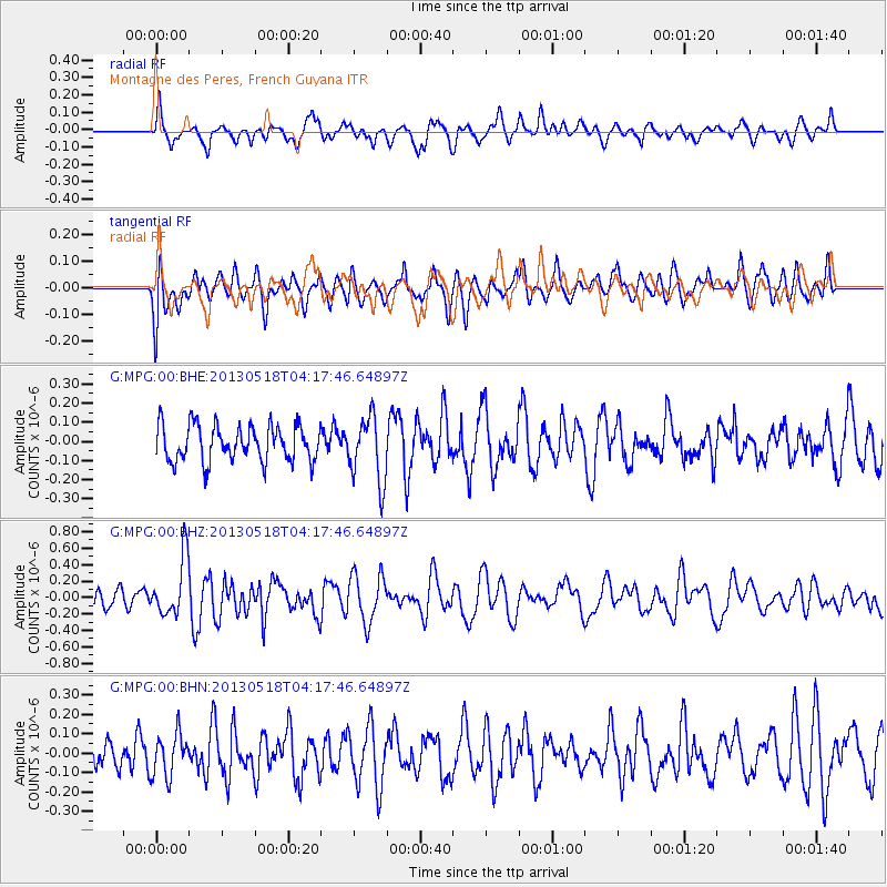
MPG Montagne des Peres, French Guyana - Earthquake Result Viewer
*The percent match for this event was below the threshold and hence no stack was calculated.
| Earthquake location: |
South Of Africa |
| Earthquake latitude/longitude: |
-53.1/22.1 |
| Earthquake time(UTC): |
2013/05/18 (138) 04:05:42 GMT |
| Earthquake Depth: |
10 km |
| Earthquake Magnitude: |
5.6 MW, 5.5 MB, 5.6 MW |
| Earthquake Catalog/Contributor: |
NEIC PDE/NEIC PDE-W |
|
| Network: |
G GEOSCOPE |
| Station: |
MPG Montagne des Peres, French Guyana |
| Lat/Lon: |
5.11 N/52.64 W |
| Elevation: |
147 m |
|
| Distance: |
85.0 deg |
| Az: |
285.294 deg |
| Baz: |
144.246 deg |
| Ray Param: |
$rayparam |
*The percent match for this event was below the threshold and hence was not used in the summary stack. |
|
| Radial Match: |
53.035534 % |
| Radial Bump: |
400 |
| Transverse Match: |
50.886482 % |
| Transverse Bump: |
400 |
| SOD ConfigId: |
512894 |
| Insert Time: |
2013-09-14 06:28:44.539 +0000 |
| GWidth: |
2.5 |
| Max Bumps: |
400 |
| Tol: |
0.001 |
|
Signal To Noise
| Channel | StoN | STA | LTA |
| G:MPG:00:BHZ:20130518T04:17:46.64897Z | 2.2845294 | 3.4912208E-7 | 1.5282014E-7 |
| G:MPG:00:BHN:20130518T04:17:46.64897Z | 1.0647674 | 1.09835405E-7 | 1.0315437E-7 |
| G:MPG:00:BHE:20130518T04:17:46.64897Z | 1.8010668 | 1.6994491E-7 | 9.4357915E-8 |
| Arrivals |
| Ps | |
| PpPs | |
| PsPs/PpSs | |


