You are here: Home > Network List > NI - North-East Italy Broadband Network Stations List
> Station CGRP Cima Grappa > Earthquake Result Viewer
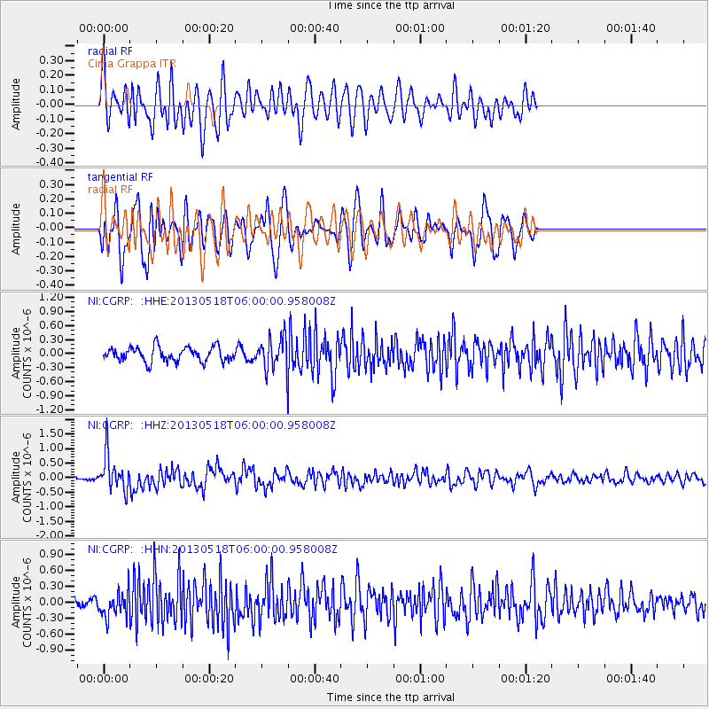
CGRP Cima Grappa - Earthquake Result Viewer
*The percent match for this event was below the threshold and hence no stack was calculated.
| Earthquake location: |
Near East Coast Of Honshu, Japan |
| Earthquake latitude/longitude: |
37.7/141.5 |
| Earthquake time(UTC): |
2013/05/18 (138) 05:47:59 GMT |
| Earthquake Depth: |
39 km |
| Earthquake Magnitude: |
6.0 MW, 5.5 MS, 6.0 MW, 6.1 MB |
| Earthquake Catalog/Contributor: |
NEIC PDE/NEIC PDE-W |
|
| Network: |
NI North-East Italy Broadband Network |
| Station: |
CGRP Cima Grappa |
| Lat/Lon: |
45.88 N/11.80 E |
| Elevation: |
1757 m |
|
| Distance: |
85.3 deg |
| Az: |
327.345 deg |
| Baz: |
37.761 deg |
| Ray Param: |
$rayparam |
*The percent match for this event was below the threshold and hence was not used in the summary stack. |
|
| Radial Match: |
59.967113 % |
| Radial Bump: |
400 |
| Transverse Match: |
62.559135 % |
| Transverse Bump: |
400 |
| SOD ConfigId: |
512894 |
| Insert Time: |
2013-09-14 06:53:31.175 +0000 |
| GWidth: |
2.5 |
| Max Bumps: |
400 |
| Tol: |
0.001 |
|
Signal To Noise
| Channel | StoN | STA | LTA |
| NI:CGRP: :HHZ:20130518T06:00:00.958008Z | 9.831026 | 6.0486667E-7 | 6.15263E-8 |
| NI:CGRP: :HHN:20130518T06:00:00.958008Z | 3.0263598 | 2.4013298E-7 | 7.934713E-8 |
| NI:CGRP: :HHE:20130518T06:00:00.958008Z | 2.094527 | 3.208555E-7 | 1.5318756E-7 |
| Arrivals |
| Ps | |
| PpPs | |
| PsPs/PpSs | |


