J05D Fort Rock, OR, USA - Earthquake Result Viewer
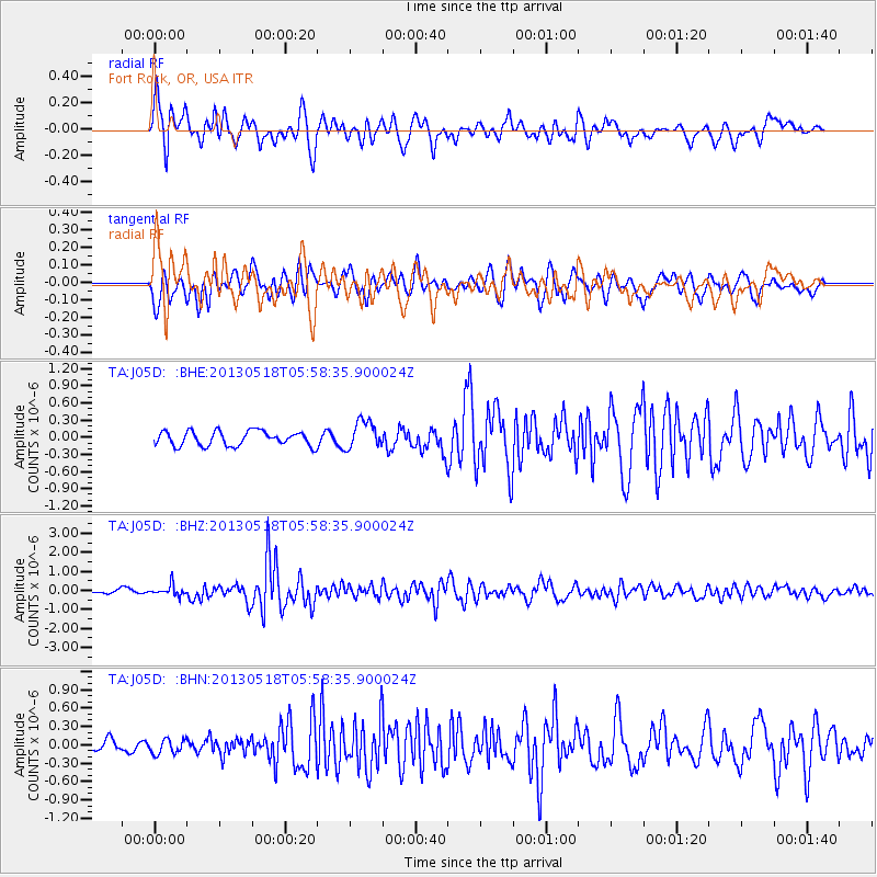
Earthquake location: Near East Coast Of Honshu, Japan
Earthquake latitude/longitude: 37.7/141.5
Earthquake time(UTC): 2013/05/18 (138) 05:47:59 GMT
Earthquake Depth: 39 km
Earthquake Magnitude: 6.0 MW, 5.5 MS, 6.0 MW, 6.1 MB
Earthquake Catalog/Contributor: NEIC PDE/NEIC PDE-W
Network: TA USArray Transportable Network (new EarthScope stations)
Station: J05D Fort Rock, OR, USA
Lat/Lon: 43.28 N/121.23 W
Elevation: 1541 m
Distance: 69.9 deg
Az: 50.451 deg
Baz: 303.162 deg
Ray Param: 0.055241607
Estimated Moho Depth: 32.5 km
Estimated Crust Vp/Vs: 1.92
Assumed Crust Vp: 6.597 km/s
Estimated Crust Vs: 3.441 km/s
Estimated Crust Poisson's Ratio: 0.31
Radial Match: 81.706955 %
Radial Bump: 400
Transverse Match: 65.21791 %
Transverse Bump: 400
SOD ConfigId: 512894
Insert Time: 2013-09-14 07:04:14.294 +0000
GWidth: 2.5
Max Bumps: 400
Tol: 0.001

Signal To Noise

ChannelStoNSTALTA
TA:J05D: :BHZ:20130518T05:58:35.900024Z2.3072672.7848816E-71.2070045E-7
TA:J05D: :BHN:20130518T05:58:35.900024Z0.868749441.2182042E-71.4022503E-7
TA:J05D: :BHE:20130518T05:58:35.900024Z1.93042432.455982E-71.2722498E-7
Arrivals
Ps4.7 SECOND
PpPs14 SECOND
PsPs/PpSs19 SECOND