You are here: Home > Network List > TA - USArray Transportable Network (new EarthScope stations) Stations List
> Station L48A N Adams, MI, USA > Earthquake Result Viewer
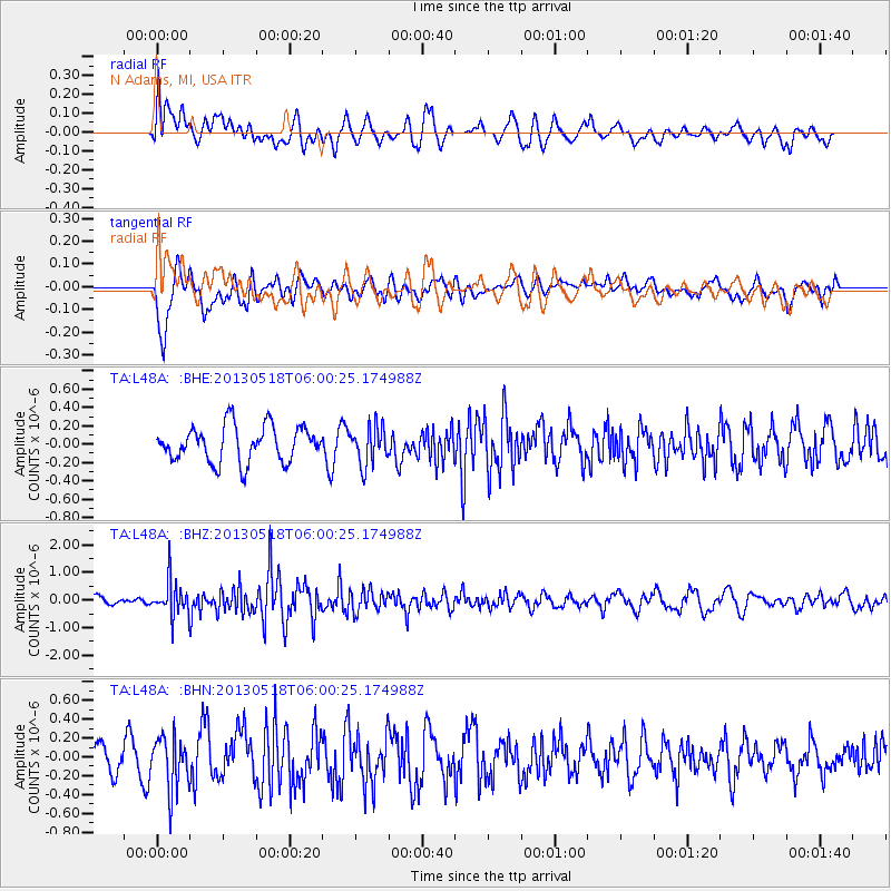
L48A N Adams, MI, USA - Earthquake Result Viewer
*The percent match for this event was below the threshold and hence no stack was calculated.
| Earthquake location: |
Near East Coast Of Honshu, Japan |
| Earthquake latitude/longitude: |
37.7/141.5 |
| Earthquake time(UTC): |
2013/05/18 (138) 05:47:59 GMT |
| Earthquake Depth: |
39 km |
| Earthquake Magnitude: |
6.0 MW, 5.5 MS, 6.0 MW, 6.1 MB |
| Earthquake Catalog/Contributor: |
NEIC PDE/NEIC PDE-W |
|
| Network: |
TA USArray Transportable Network (new EarthScope stations) |
| Station: |
L48A N Adams, MI, USA |
| Lat/Lon: |
41.94 N/84.43 W |
| Elevation: |
369 m |
|
| Distance: |
90.3 deg |
| Az: |
32.397 deg |
| Baz: |
325.294 deg |
| Ray Param: |
$rayparam |
*The percent match for this event was below the threshold and hence was not used in the summary stack. |
|
| Radial Match: |
47.312122 % |
| Radial Bump: |
400 |
| Transverse Match: |
66.18828 % |
| Transverse Bump: |
400 |
| SOD ConfigId: |
512894 |
| Insert Time: |
2013-09-14 07:06:22.572 +0000 |
| GWidth: |
2.5 |
| Max Bumps: |
400 |
| Tol: |
0.001 |
|
Signal To Noise
| Channel | StoN | STA | LTA |
| TA:L48A: :BHZ:20130518T06:00:25.174988Z | 3.4923255 | 6.2566676E-7 | 1.7915477E-7 |
| TA:L48A: :BHN:20130518T06:00:25.174988Z | 1.8420929 | 2.7664595E-7 | 1.5018023E-7 |
| TA:L48A: :BHE:20130518T06:00:25.174988Z | 1.0652776 | 2.071087E-7 | 1.9441758E-7 |
| Arrivals |
| Ps | |
| PpPs | |
| PsPs/PpSs | |


