You are here: Home > Network List > TA - USArray Transportable Network (new EarthScope stations) Stations List
> Station M52A Chesterland, OH, USA > Earthquake Result Viewer
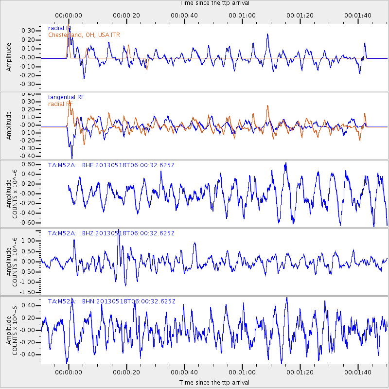
M52A Chesterland, OH, USA - Earthquake Result Viewer
*The percent match for this event was below the threshold and hence no stack was calculated.
| Earthquake location: |
Near East Coast Of Honshu, Japan |
| Earthquake latitude/longitude: |
37.7/141.5 |
| Earthquake time(UTC): |
2013/05/18 (138) 05:47:59 GMT |
| Earthquake Depth: |
39 km |
| Earthquake Magnitude: |
6.0 MW, 5.5 MS, 6.0 MW, 6.1 MB |
| Earthquake Catalog/Contributor: |
NEIC PDE/NEIC PDE-W |
|
| Network: |
TA USArray Transportable Network (new EarthScope stations) |
| Station: |
M52A Chesterland, OH, USA |
| Lat/Lon: |
41.54 N/81.36 W |
| Elevation: |
382 m |
|
| Distance: |
91.9 deg |
| Az: |
30.705 deg |
| Baz: |
327.368 deg |
| Ray Param: |
$rayparam |
*The percent match for this event was below the threshold and hence was not used in the summary stack. |
|
| Radial Match: |
71.47337 % |
| Radial Bump: |
400 |
| Transverse Match: |
59.07516 % |
| Transverse Bump: |
329 |
| SOD ConfigId: |
512894 |
| Insert Time: |
2013-09-14 07:07:05.827 +0000 |
| GWidth: |
2.5 |
| Max Bumps: |
400 |
| Tol: |
0.001 |
|
Signal To Noise
| Channel | StoN | STA | LTA |
| TA:M52A: :BHZ:20130518T06:00:32.625Z | 2.751267 | 3.811541E-7 | 1.3853767E-7 |
| TA:M52A: :BHN:20130518T06:00:32.625Z | 1.8625554 | 3.0046135E-7 | 1.6131673E-7 |
| TA:M52A: :BHE:20130518T06:00:32.625Z | 0.94265264 | 1.5363348E-7 | 1.6297994E-7 |
| Arrivals |
| Ps | |
| PpPs | |
| PsPs/PpSs | |


