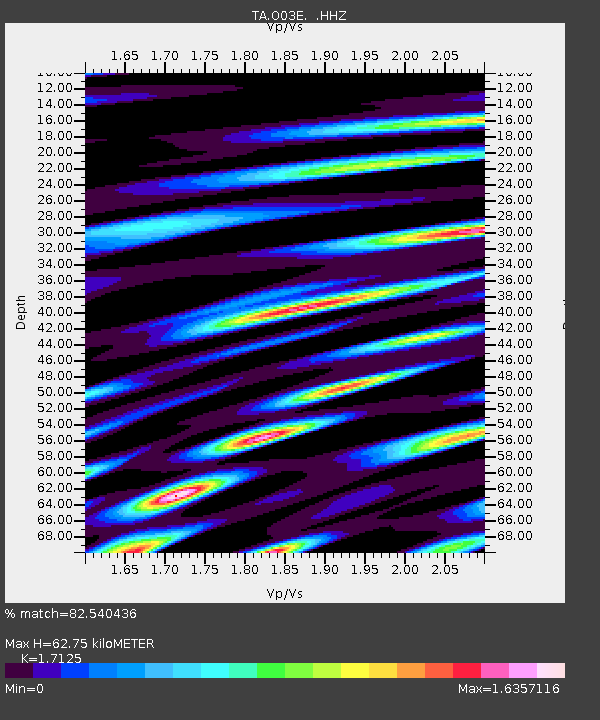
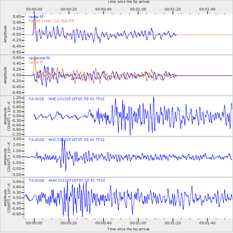
O03E Paynes Creek, CA, USA - Earthquake Result Viewer

Earthquake location: Near East Coast Of Honshu, Japan
Earthquake latitude/longitude: 37.7/141.5
Earthquake time(UTC): 2013/05/18 (138) 05:47:59 GMT
Earthquake Depth: 39 km
Earthquake Magnitude: 6.0 MW, 5.5 MS, 6.0 MW, 6.1 MB
Earthquake Catalog/Contributor: NEIC PDE/NEIC PDE-W
Network: TA USArray Transportable Network (new EarthScope stations)
Station: O03E Paynes Creek, CA, USA
Lat/Lon: 40.29 N/121.80 W
Elevation: 967 m
Distance: 71.2 deg
Az: 53.342 deg
Baz: 303.746 deg
Ray Param: 0.0543941
Estimated Moho Depth: 62.75 km
Estimated Crust Vp/Vs: 1.71
Assumed Crust Vp: 6.566 km/s
Estimated Crust Vs: 3.834 km/s
Estimated Crust Poisson's Ratio: 0.24
Radial Match: 82.540436 %
Radial Bump: 400
Transverse Match: 67.967636 %
Transverse Bump: 400
SOD ConfigId: 512894
Insert Time: 2013-09-14 07:08:00.315 +0000
GWidth: 2.5
Max Bumps: 400
Tol: 0.001

Signal To Noise

ChannelStoNSTALTA
TA:O03E: :HHZ:20130518T05:58:43.750Z3.05272032.7264446E-78.931197E-8
TA:O03E: :HHN:20130518T05:58:43.750Z1.3282321.6527922E-71.244355E-7
TA:O03E: :HHE:20130518T05:58:43.750Z1.62597931.8313311E-71.1262943E-7
Arrivals
Ps7.1 SECOND
PpPs25 SECOND
PsPs/PpSs32 SECOND