You are here: Home > Network List > TA - USArray Transportable Network (new EarthScope stations) Stations List
> Station O45A Potomac, IL, USA > Earthquake Result Viewer
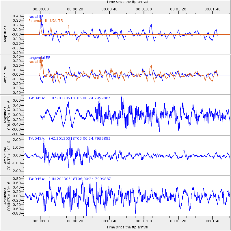
O45A Potomac, IL, USA - Earthquake Result Viewer
*The percent match for this event was below the threshold and hence no stack was calculated.
| Earthquake location: |
Near East Coast Of Honshu, Japan |
| Earthquake latitude/longitude: |
37.7/141.5 |
| Earthquake time(UTC): |
2013/05/18 (138) 05:47:59 GMT |
| Earthquake Depth: |
39 km |
| Earthquake Magnitude: |
6.0 MW, 5.5 MS, 6.0 MW, 6.1 MB |
| Earthquake Catalog/Contributor: |
NEIC PDE/NEIC PDE-W |
|
| Network: |
TA USArray Transportable Network (new EarthScope stations) |
| Station: |
O45A Potomac, IL, USA |
| Lat/Lon: |
40.25 N/87.72 W |
| Elevation: |
208 m |
|
| Distance: |
90.2 deg |
| Az: |
35.405 deg |
| Baz: |
323.123 deg |
| Ray Param: |
$rayparam |
*The percent match for this event was below the threshold and hence was not used in the summary stack. |
|
| Radial Match: |
70.27774 % |
| Radial Bump: |
400 |
| Transverse Match: |
73.16755 % |
| Transverse Bump: |
400 |
| SOD ConfigId: |
512894 |
| Insert Time: |
2013-09-14 07:08:06.091 +0000 |
| GWidth: |
2.5 |
| Max Bumps: |
400 |
| Tol: |
0.001 |
|
Signal To Noise
| Channel | StoN | STA | LTA |
| TA:O45A: :BHZ:20130518T06:00:24.799988Z | 3.257364 | 6.410175E-7 | 1.9679025E-7 |
| TA:O45A: :BHN:20130518T06:00:24.799988Z | 1.8843585 | 2.753642E-7 | 1.4613151E-7 |
| TA:O45A: :BHE:20130518T06:00:24.799988Z | 1.1491573 | 2.4793198E-7 | 2.1575113E-7 |
| Arrivals |
| Ps | |
| PpPs | |
| PsPs/PpSs | |


