You are here: Home > Network List > TA - USArray Transportable Network (new EarthScope stations) Stations List
> Station R41A Rosebud, MO, USA > Earthquake Result Viewer
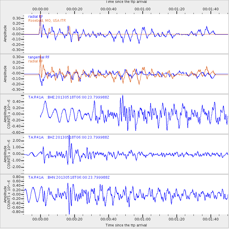
R41A Rosebud, MO, USA - Earthquake Result Viewer
*The percent match for this event was below the threshold and hence no stack was calculated.
| Earthquake location: |
Near East Coast Of Honshu, Japan |
| Earthquake latitude/longitude: |
37.7/141.5 |
| Earthquake time(UTC): |
2013/05/18 (138) 05:47:59 GMT |
| Earthquake Depth: |
39 km |
| Earthquake Magnitude: |
6.0 MW, 5.5 MS, 6.0 MW, 6.1 MB |
| Earthquake Catalog/Contributor: |
NEIC PDE/NEIC PDE-W |
|
| Network: |
TA USArray Transportable Network (new EarthScope stations) |
| Station: |
R41A Rosebud, MO, USA |
| Lat/Lon: |
38.30 N/91.38 W |
| Elevation: |
257 m |
|
| Distance: |
90.0 deg |
| Az: |
38.84 deg |
| Baz: |
320.809 deg |
| Ray Param: |
$rayparam |
*The percent match for this event was below the threshold and hence was not used in the summary stack. |
|
| Radial Match: |
77.3803 % |
| Radial Bump: |
400 |
| Transverse Match: |
69.78206 % |
| Transverse Bump: |
338 |
| SOD ConfigId: |
512894 |
| Insert Time: |
2013-09-14 07:09:22.996 +0000 |
| GWidth: |
2.5 |
| Max Bumps: |
400 |
| Tol: |
0.001 |
|
Signal To Noise
| Channel | StoN | STA | LTA |
| TA:R41A: :BHZ:20130518T06:00:23.799988Z | 3.65011 | 5.242553E-7 | 1.4362726E-7 |
| TA:R41A: :BHN:20130518T06:00:23.799988Z | 2.409414 | 2.670689E-7 | 1.1084392E-7 |
| TA:R41A: :BHE:20130518T06:00:23.799988Z | 1.2708739 | 2.0418017E-7 | 1.6066123E-7 |
| Arrivals |
| Ps | |
| PpPs | |
| PsPs/PpSs | |


